Port Pirie Regional Council

Port Pirie Regional Council
Regional Council of Port Pirie
Australia-Map-SA-LGA-PortPirie.png
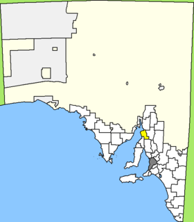
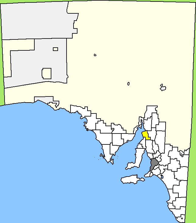
Lage des Port Pirie Regional Council in South Australia
Gliederung
Staat: Australien Australien
Bundesstaat: Flag of South Australia.svg South Australia
Verwaltungssitz: Port Pirie
Daten und Zahlen
Einwohner: 17.142 (2006) [1]
-33.176944444444138.01027777778

Der Regional Council of Port Pirie ist ein lokales Verwaltungsgebiet (LGA) im australischen Bundesstaat South Australia. Das Gebiet hat etwa 17.000 Einwohner.

Port Pirie liegt etwa 200 km nordwestlich der Metropole Adelaide wenige Kilometer landeinwärts vom Spencer-Golf. Das Gebiet beinhaltet 26 Ortsteile und Ortschaften: Bungama, Butler Bridge, Clements Gap, Cockeys Crossing, Collinsfield, Coonamia, Crystal Brook, Ingrams Gap, Keilli, Koolunga, Lower Broughton, Merriton, Napperby, Nelshaby, Nurom Siding, Pirie South, Pirie West, Port Pirie, Redhill, Risdon Park, Risdon Park South, Solomontown, Wandearah East, Wandearah Siding, Wandearah West und Warnertown. Der Verwaltungssitz des Councils befindet sich in der Stadt Port Pirie im Norden der LGA.

Verwaltung

Der Council von Port Pirie hat elf Mitglieder, die zehn Councillor und der Vorsitzende und Mayor (Bürgermeister) des Councils werden von den Bewohnern der LGA gewählt. Port Pirie ist nicht in Bezirke untergliedert.

Weblinks

Einzelnachweise

  1. Australian Bureau of Statistics (25. Oktober 2007): Port Pirie City and Dists (M) (Local Government Area) (Englisch). 2006 Census QuickStats. Abgerufen am 6. April 2010.

Wikimedia Foundation.

Игры ⚽ Поможем написать курсовую

Schlagen Sie auch in anderen Wörterbüchern nach:

  • Port Pirie Regional Council — Infobox Australian Place | type = lga name = Port Pirie Regional Council state = sa caption = Location of Port Pirie Regional Council pop = 22,000 area = est = seat = mayor = Geoff Brock region = logosize = url =… …   Wikipedia

  • Port Pirie — Staat: Australien Bundesstaat …   Deutsch Wikipedia

  • Port Pirie, South Australia — Infobox Australian Place | type = city name = Port Pirie state = sa caption = Location of Port Pirie in South Australia (red) pop = 13,206 (2006 Census) poprank = postcode = 5540 density = est = 1845 elevation = 4 area = timezone = ACST utc =… …   Wikipedia

  • Wakefield Regional Council — South Australia Location of Wakefield Regional Council Population …   Wikipedia

  • District Council of Barunga West — South Australia Location of the District Council of Barunga West Population …   Wikipedia

  • Northern Areas Council — South Australia Location of the Northern Areas Council Population …   Wikipedia

  • District Council of Mount Remarkable — South Australia Location of the District Council of Mount Remarkable Population …   Wikipedia

  • District Council of Mallala — South Australia Location of the District Council of Mallala Population …   Wikipedia

  • District Council of Clare and Gilbert Valleys — South Australia Location of District Council of Clare and Gilbert Valleys …   Wikipedia

  • City of Port Augusta — South Australia Location of the City of Port Augusta Population …   Wikipedia

Share the article and excerpts

Direct link
Do a right-click on the link above
and select “Copy Link”