- Pyhä
-
Pyhätunturi 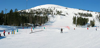
Das Skisportzentrum am Pyhätunturi
Höhe 540 m Lage Lappland, Finnland Geographische Lage 67° 1′ 0″ N, 27° 8′ 0″ O67.01666666666727.133333333333540Koordinaten: 67° 1′ 0″ N, 27° 8′ 0″ O 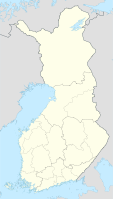

Typ Fjell Der Pyhätunturi [ˈpyhætunturi] ist ein 540 Meter hoher Fjell im Norden Finnlands. Er befindet sich im Gebiet der Gemeinde Pelkosenniemi in Zentrallappland.
Der Pyhätunturi besteht aus mehreren Gipfeln und bildet mit dem Fjell Luosto, der sich nordwestlich anschließt, eine 35 Kilometer lange Bergkette, die sich deutlich von der flachen Umgebung abhebt. Der höchste Gipfel des Pyhätunturi hat den Namen Noitakero, andere Gipfel sind Kultakero, Ukonhattu, Laakakero, Peurakero und Soutaja. Der Pyhätunturi entstand vor zwei Milliarden Jahren und besteht aus harten Quarziten, die der Erosion standhalten konnten und durch die Gletscher des Eiszeitalters zu einem runden Fjell abgeschliffen wurde. Das Schmelzwasser der Gletscher bildete zwischen den Gipfeln tief eingeschnittene Täler. Deren größtes ist das 220 Meter tiefe Isokuru-Tal zwischen den Gipfeln Kultakero und Ukonhattu.
Zusammen mit dem Luosto gehört der Pyhätunturi zum Pyhä-Luosto-Nationalpark. Am Kultakero-Gipfel befindet sich das Skisportzentrum Pyhä mit einem Hotel, zehn Skipisten und dem Informationszentrum des Nationalparks. Pyhä und das benachbarte Luosto verzeichnen insgesamt rund 110.000 Übernachtungen pro Jahr und gehören damit zu den kleineren Skisportzentren Lapplands.[1]
Einzelnachweise
- ↑ Stand 2003, Lapin liitto: Tourism in Finland and Lapland (engl.), S. 78.
Weblinks
- Website des Skisportzentrums Pyhä (finn./engl.)
- Topografische Karte


Wikimedia Foundation.