- Rainy River (Minnesota-Ontario)
-
Rainy River
Rivière à la Pluie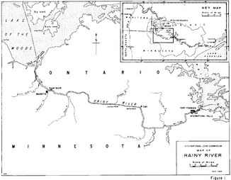
Lage und Verlauf des Rainy River
Daten Gewässerkennzahl US: 657974 Lage Grenze Minnesota (USA) / Ontario (Kanada) Flusssystem Nelson River Abfluss über Lake of the Woods → Winnipeg River → Winnipegsee → Nelson River → Hudson Bay Quellsee Rainy Lake
48° 36′ 54″ N, 93° 21′ 12″ W48.6149353-93.3532024Mündung in den Lake of the Woods 48.848593-94.6916009Koordinaten: 48° 50′ 55″ N, 94° 41′ 30″ W
48° 50′ 55″ N, 94° 41′ 30″ W48.848593-94.6916009Länge 140 km Kleinstädte International Falls, Fort Frances Gemeinden Baudette, Rainy River Bekannte Brücken Baudette-Rainy River International Bridge, Fort Frances-International Falls International Bridge Der Rainy River (französisch Rivière à la Pluie) ist ein rund 140 Kilometer langer Fluss, der einen Teil der Grenze zwischen den Vereinigten Staaten und Kanada bildet und so den Norden des US-Bundesstaates Minnesota vom Nordwesten der kanadischen Provinz Ontario trennt. Ursprung des Flusses ist der Rainy Lake (frz.: Lac à la Pluie), den er an dessen Westseite verlässt. Der Fluss fließt dann west-nordwestwärts.
Der Fluss wird von zwei Grenzbrücken überquert, der Baudette-Rainy River International Bridge zwischen Baudette und Rainy River – diese Stadt ist nach dem Fluss benannt – sowie der Fort Frances-International Falls International Bridge zwischen International Falls, Minnesota und Fort Frances, Ontario – hier wird auch mit Wasserkraft elektrischer Strom gewonnen. Auf der kanadischen Seite folgt seit 1901 die heute zu Canadian National gehörende Ontario and Rainy River Railway dem Fluss. Etwa 19 Kilometer nordwestlich von Baudette mündet der Fluss an dessen sudlichen Ende in den Lake of the Woods.
Das Einzugsgebiet des Flusses reicht ostwärts bis zu den Höhen des Landes, etwa 100 km westlich des Oberen Sees, so sich einst die südöstliche Ecke des 1670 an die Hudson’s Bay Company abgetretenen Landes befand. Der Fluss führt sei Wasser schließlich über den Winnipeg River, Lake Winnipeg und den Nelson River zur Hudson Bay.
Siehe auch
Weblinks
Kategorien:- Flusssystem Nelson River
- Fluss in Minnesota
- Fluss in Ontario
- Fluss in Nordamerika

Wikimedia Foundation.