- Reigate & Banstead
-
Borough of Reigate and Banstead 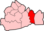
Lage in SurreyStatus Borough Region South East England Verw.grafschaft Surrey Verwaltungssitz Reigate Fläche 129,13 km² (224.) Einwohner (2007) 132.300 (141.) ONS-Code 43UF Website www.reigate-banstead.gov.uk Reigate and Banstead (oft auch Reigate & Banstead geschrieben) ist ein Verwaltungsbezirk mit dem Status eines Borough in der Grafschaft Surrey in England. Im Norden grenzt er an Greater London. Er umfasst neben dem Verwaltungssitz Reigate die Städte Banstead, Horley und Redhill.
Geschichte
- 967: Erste urkundliche Erwähnung von Banstead in einer angelsächsischen Charta aus der Zeit König Edgars.
- 1088 wird das Land um Reigate nach der Schlacht von Hastings einem der Ritter von William dem Eroberer, William de Warenne, zugesprochen, dem er außerdem den Titel Graf von Surrey verleiht.
- Um 1150 ordnen die de Warennes an, dass eine Stadt unterhalb ihrer Burg errichtet werde: Reigate.
- 12. Jahrhundert: Eine große Halle wird in Tadworth gebaut (1952 ausgegraben).
- 1539 kommt Horley Manor nach der Auflösung der Klöster an Henry VIII.
- 1563 gibt Königin Elizabeth Lord Howard of Effingham, welcher in der Priorei von Reigate lebt, die Kronländereien des Weilers Kingswoode (heute: Kingswood).
- 1602 wird Horley Manor Eigentum des Christ's Hospital in London.
- 1818 schlägt die Geburtsstunde von Redhill aufgrund des Baus einer Kreuzung an der Fernstraße London - Brighton.
- 1. April 1974: Der neue Bezirk Reigate and Banstead entsteht aus der Fusion des Borough of Reigate, des Banstead Urban District und einem Teil des Dorking and Horley Rural District.
Partnerstadt
Die Städtepartnerschaft zwischen Eschweiler in Nordrhein-Westfalen und dem englischen Borough of Reigate and Banstead wird mit Unterzeichnung der Partnerschaftsurkunde durch die Bürgermeister und Stadtdirektoren am 4. Mai 1985 ins Leben gerufen. Am 26. September 1989 wird der „Bahnhofsplatz“ vor dem Eschweiler Hauptbahnhof in „Reigate & Banstead-Platz“ offiziell umbenannt.
Weblinks

Wikimedia Foundation.