- Reigate and Banstead
-
Borough of Reigate and Banstead 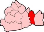
Lage in SurreyStatus Borough Region South East England Verw.grafschaft Surrey Verwaltungssitz Reigate Fläche 129,13 km² (224.) Einwohner 132.300 (141.) ONS-Code 43UF Website www.reigate-banstead.gov.uk Reigate and Banstead (oft auch Reigate & Banstead geschrieben) ist ein Verwaltungsbezirk mit dem Status eines Borough in der Grafschaft Surrey in England. Im Norden grenzt er an Greater London. Er umfasst neben dem Verwaltungssitz Reigate die Städte Banstead, Horley und Redhill.
Geschichte
- 967: Erste urkundliche Erwähnung von Banstead in einer angelsächsischen Charta aus der Zeit König Edgars.
- 1088 wird das Land um Reigate nach der Schlacht von Hastings einem der Ritter von William dem Eroberer, William de Warenne, zugesprochen, dem er außerdem den Titel Graf von Surrey verleiht.
- Um 1150 ordnen die de Warennes an, dass eine Stadt unterhalb ihrer Burg errichtet werde: Reigate.
- 12. Jahrhundert: Eine große Halle wird in Tadworth gebaut (1952 ausgegraben).
- 1539 kommt Horley Manor nach der Auflösung der Klöster an Henry VIII.
- 1563 gibt Königin Elizabeth Lord Howard of Effingham, welcher in der Priorei von Reigate lebt, die Kronländereien des Weilers Kingswoode (heute: Kingswood).
- 1602 wird Horley Manor Eigentum des Christ's Hospital in London.
- 1818 schlägt die Geburtsstunde von Redhill aufgrund des Baus einer Kreuzung an der Fernstraße London - Brighton.
- 1. April 1974: Der neue Bezirk Reigate and Banstead entsteht aus der Fusion des Borough of Reigate, des Banstead Urban District und einem Teil des Dorking and Horley Rural District.
Partnerstadt
Die Städtepartnerschaft zwischen Eschweiler in Nordrhein-Westfalen und dem englischen Borough of Reigate and Banstead wird mit Unterzeichnung der Partnerschaftsurkunde durch die Bürgermeister und Stadtdirektoren am 4. Mai 1985 ins Leben gerufen. Am 26. September 1989 wird der „Bahnhofsplatz“ vor dem Eschweiler Hauptbahnhof in „Reigate & Banstead-Platz“ offiziell umbenannt.
Weblinks

Elmbridge | Epsom and Ewell | Guildford | Mole Valley | Reigate and Banstead | Runnymede | Spelthorne | Surrey Heath | Tandridge | Waverley | Woking
Wikimedia Foundation.
Schlagen Sie auch in anderen Wörterbüchern nach:
Reigate and Banstead — is a local government district with borough status in east Surrey England. It covers the towns of Reigate, Banstead, Redhill and Horley.The district was formed on 1 April 1974 under the Local Government Act 1972. It was a merger of the former… … Wikipedia
Reigate and Banstead — ▪ district, England, United Kingdom borough (district), administrative and historic county of Surrey, southeastern England immediately south of Greater London. Named after the two principal locales of the district, Reigate and Banstead… … Universalium
Reigate and Banstead local elections — One third of Reigate and Banstead Council in Surrey, England is elected each year, followed by one year without election.Political controlConservative 1973 1991No overall control 1991 2000Conservative 2000 presentCouncil electionsReigate and… … Wikipedia
Reigate and Banstead Residents Association — The Reigate and Banstead Residents Association holds six seats in the Reigate and Banstead borough in Surrey, England. [ [http://news.bbc.co.uk/1/shared/vote2007/councils/html/43uf.stm BBC news] ] In Nork Michael John Selby for the Nork Residents … Wikipedia
Reigate Castle — (coord|51|13|48|N|0|11|16|W|) is a ruined castle in the market town of Reigate in the county of Surrey, England.EstablishmentKing William I granted the land around Reigate to one of his supporters, William de Warenne, who was created Earl of… … Wikipedia
Reigate Heath Windmill — The mill in 2007 Origin Mill name Reigate Heath mill Mill location … Wikipedia
Reigate — Foto einer Mühle in Reigate Koordinaten … Deutsch Wikipedia
Reigate & Banstead — Borough of Reigate and Banstead Lage in Surrey Status Borough Region South East England Verw.grafschaft … Deutsch Wikipedia
Banstead — infobox UK place country = England official name= Banstead map type= Surrey latitude= 51.322 longitude= 0.204 population = 8,512 [ [http://neighbourhood.statistics.gov.uk/dissemination/LeadKeyFigures.do?a=7 b=5942963 c=SM7+2NN d=14 e=16 g=490903… … Wikipedia
Reigate — infobox UK place country = England latitude= 51.2301 longitude= 0.1880 official name= Reigate map type= Surrey static static image caption=Reigate Heath Windmill population = 21,820 shire district= Reigate and Banstead shire county = Surrey… … Wikipedia
Reigate and Banstead


18+
© Academic, 2000-2026
- Kontaktieren Sie uns: Unterstützung, Werbung
Wörterbücher Export, schritte mit PHP, Joomla, Drupal, WordPress, MODx.