Rural City of Murray Bridge
- Rural City of Murray Bridge
-
| Rural City of Murray Bridge |
 |
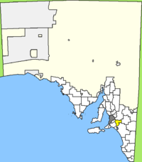
| Lage der Murray Bridge Rural City in South Australia |
| Basisdaten |
| Bundesstaat: |
South Australia |
| Hauptort: |
Murray Bridge |
| Fläche: |
1.828 km² |
| Einwohner: |
18.364 (Juni 2006) |
| Wards: |
3 |
| Ortschaften: |
52 |
Die Rural City of Murray Bridge ist ein lokales Verwaltungsgebiet (LGA) im australischen Bundesstaat South Australia. Das Gebiet ist 1.828 km² groß und hat etwa 18.000 Einwohner.
Murray Bridge liegt in den Murray Lands an der Mündung des Flusses Murray in den Lake Alexandrina. Das Gebiet grenzt an den Großraum der Metropole Adelaide und liegt etwa 65 km westlich des Stadtzentrums. Die LGA beinhaltet 52 Ortsteile und Ortschaften. Der Verwaltungssitz des Councils befindet sich in der Stadt Murray Bridge im Nordwesten der LGA, die etwa 14.000 Einwohner hat.
Verwaltung
Der Council von Murray Bridge hat zehn Mitglieder, neun Councillor werden von den Bewohnern der drei Wards gewählt (je drei aus Brinkley, Mobilong und Monarto Ward). Diese drei Bezirke sind unabhängig von den Ortschaften festgelegt. Der Ratsvorsitzende und Mayor (Bürgermeister) wird zusätzlich von allen Bewohnern der LGA gewählt.
Weblinks
-35.12139.273888888897Koordinaten: 35° 7′ S, 139° 16′ O
Wikimedia Foundation.
Schlagen Sie auch in anderen Wörterbüchern nach:
Rural City of Murray Bridge — Infobox Australian Place | type = lga name = Rural City of Murray Bridge state = sa caption = Position of the Rural City of Murray Bridge in SA pop = area = est = coordinates = coord| 35.1186|139.2838|display=inline,title|region:AU SA type:adm2nd … Wikipedia
Murray Bridge, South Australia — Murray Bridge South Australia Main street of Murray Bridge Population … Wikipedia
Murray Bridge Rural City — Rural City of Murray Bridge Lage der Murray Bridge Rural City in South Australia Gliederung … Deutsch Wikipedia
Murray Bridge — Staat: Australien Bundesstaat … Deutsch Wikipedia
Ville de Murray Bridge — 35° 07′ 07″ S 139° 17′ 02″ E / 35.1186, 139.2838 … Wikipédia en Français
District Council of Karoonda East Murray — South Australia Location of the District Council of Karoonda East Murray … Wikipedia
City of Onkaparinga — South Australia Population: 160,404(2009 … Wikipedia
City of Victor Harbor — South Australia Population: 13,608(2009)[1] Area: 386.5 km² (149.2 sq mi) … Wikipedia
City of Lake Macquarie — This article is about the City of Lake Macquarie. For the lake, see Lake Macquarie (New South Wales). City of Lake Macquarie New South Wales Location in … Wikipedia
City of Hawkesbury — New South Wales Location in New South Wales Population … Wikipedia

