Rutland Water

Rutland Water
Rutland Water

Photo-request.svg

Bild gesucht 

BW

Geographische Lage Rutland, England
Zuflüsse Gwash
Abfluss Gwash → Welland
Orte am Ufer Empingham, Hambleton, Oakham
Größere Städte in der Nähe Peterborough
Daten
Koordinaten 52° 39′ 36″ N, 0° 36′ 30″ W52.659934-0.6084108Koordinaten: 52° 39′ 36″ N, 0° 36′ 30″ W
Rutland Water (England)
Rutland Water
Fläche 12,6 km²f5

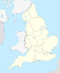
Rutland Water ist ein Stausee im Zentrum der englischen Unitary Authority Rutland. Mit einer Fläche von 12,6 km² ist er der flächenmäßig größte Stausee Englands, im Wasservolumen wird er nur noch vom Kielder Water in Northumberland übertroffen.

Der Damm, der den Gwash aufstaute, wurde 1975 errichtet. Während der Planungs- und Bauphase wurde der See Empingham Reservoir genannt. Einige Orte, wie Nether Hambleton und Middle Hambleton wurden überflutet.

Der See hat die Form eines nach Westen geöffneten liegenden Us und umfließt die Hambleton-Halbinsel, die sich weit in den Stausee hineinschiebt.

Der Stausee wird zur Wasserversorgung der umliegenden Dörfer und Städte (insbesondere Peterborough) und zu Erholungs- und Freizeitzwecken genutzt. Der Westteil ist ein bedeutendes Naturschutzgebiet, das als Überwinterplatz für Gänsevögel und Brutstätte für Fischadler dient.


Wikimedia Foundation.

Игры ⚽ Нужно сделать НИР?

Schlagen Sie auch in anderen Wörterbüchern nach:

  • Rutland Water — Infobox lake lake name = Rutland Water image lake = Rutland Water swans (508268544).jpg caption lake = image bathymetry = caption bathymetry = location = Rutland coords = coord|52|40|N|0|40|W|region:GB type:waterbody|display=inline,title type =… …   Wikipedia

  • Rutland Water — Sp Rãtland Vòteris Ap Rutland Water L ež. Jungtinėje Karalystėje (Anglijoje) …   Pasaulio vietovardžiai. Internetinė duomenų bazė

  • Rutland — Basisdaten Status Unitary Authority Zeremonielle Grafschaft Traditionelle Grafschaft Region East Midlands …   Deutsch Wikipedia

  • Rutland — Saltar a navegación, búsqueda Rutlan es el más pequeño de los condados tradicionales de Inglaterra, en el Reino Unido. Localización del condado de Rutland. Limita al oeste y al norte con Leicestershire, al noroeste con Lincolnshire y al sudoeste… …   Wikipedia Español

  • Rutland — For other uses, see Rutland (disambiguation). Coordinates: 52°39′20.00″N 0°39′30.00″W / 52.65556°N 0.65833°W / 52.65556; 0.65833 …   Wikipedia

  • Rutland — /rut leuhnd/, n. 1. a city in W Vermont. 18,436. 2. Rutlandshire. * * * ▪ Vermont, United States       city, seat (1784) of Rutland county, south central Vermont, U.S. It lies between the Green Mountains and the Taconic Range on Otter Creek. In… …   Universalium

  • Rutland — Rutland, ND U.S. city in North Dakota Population (2000): 220 Housing Units (2000): 102 Land area (2000): 0.378438 sq. miles (0.980149 sq. km) Water area (2000): 0.000000 sq. miles (0.000000 sq. km) Total area (2000): 0.378438 sq. miles (0.980149… …   StarDict's U.S. Gazetteer Places

  • Rutland Barrington — (15 January 1853 ndash; 31 May 1922) was an English singer, actor, comedian, and Edwardian musical comedy star. Best remembered for originating the lyric baritone roles in the Gilbert and Sullivan operas from 1877 to 1896, his performing career… …   Wikipedia

  • Rutland (town), Vermont — Rutland is a town in Rutland County, Vermont, United States. The population was 4,038 at the 2000 census. Rutland completely surrounds the city of Rutland, which is incorporated separately from the town of Rutland.GeographyRutland is located at… …   Wikipedia

  • Rutland Barrington — Saltar a navegación, búsqueda Rutland Barrington Jessie Bond y Barrington en 1891 Nombre real George Rutland Fleet …   Wikipedia Español

Share the article and excerpts

Direct link
Do a right-click on the link above
and select “Copy Link”