Røldalsvatnet

Røldalsvatnet
Røldalsvatnet

Photo-request.svg

Bild gesucht 

BW

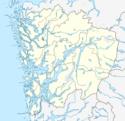
Geographische Lage Odda (Hordaland)
Daten
Koordinaten 59° 47′ 42″ N, 6° 46′ 31″ O59.7956.7752777777778380Koordinaten: 59° 47′ 42″ N, 6° 46′ 31″ O
Røldalsvatnet (Hordaland)
Røldalsvatnet
Höhe über Meeresspiegel 380 moh.
Fläche 6,99 km²dep1f5
Umfang 20,64 kmdep1f9

Røldalsvatnet ist der Name eines Sees in Norwegen. Er liegt in der Kommune Odda (Hordaland). Die Europastraße 134 und der Riksvei 13 verlaufen an der Westseite des Sees. Nördlich des Sees befindet sich die Stabkirche Røldal.

Siehe auch

Liste der Seen in Norwegen


Wikimedia Foundation.

Игры ⚽ Поможем решить контрольную работу

Schlagen Sie auch in anderen Wörterbüchern nach:

  • Røldalsvatnet — infobox lake lake name = Ringedalsvatnet basin countries= Norway location = Odda (Hordaland) inflow = outflow = area = 6.99 km² elevation = 380 m residence time = shore = 20.64 km depth = max depth = volume = coords =… …   Wikipedia

  • Odda — This article is about the Norwegian municipality and town. For the English ealdorman, see Ealdorman Odda. For the English earl, see Earl Odda. Odda kommune   Municipality   …   Wikipedia

  • Mjøsa — View northwards from Minnesund, Eidsvoll Location Akershus, Hedmark, Oppland Coordinates …   Wikipedia

  • Østensjøvannet — photo: Hans Petter Fjeld Location Oslo Coordinates …   Wikipedia

  • Norsjø — I♥U Norsjø Lake Norsjo in Gvarv Location Skien, Nome, Sauherad (Telemark) Coordinates …   Wikipedia

  • Mørsvikvatnet — Location Sørfold, Nordland Coordinates 67°43′26″N 15°55′5″E …   Wikipedia

  • List of lakes in Norway — Lake Ulvsvann in Skien, Telemark Lake Ovre Sjodal …   Wikipedia

  • Øyeren — Map of Øyeren and surrounds Location …   Wikipedia

  • Blåsjø — Location Bykle, Aust Agder Hjelmeland, Rogaland Suldal, Rogaland Coordinates …   Wikipedia

  • Møsvatn — Storfjorden on Møsvatn in direction west …   Wikipedia

Share the article and excerpts

Direct link
Do a right-click on the link above
and select “Copy Link”