Scrub Island (Anguilla)

Scrub Island (Anguilla)

Vorlage:Infobox Insel/Wartung/Höhe fehlt

Scrub Island
Strand von Scrub Island
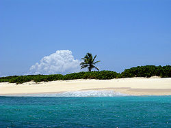
Gewässer Karibisches Meer
Geographische Lage 18° 17′ 15″ N, 62° 56′ 50″ W18.2875-62.947222222222Koordinaten: 18° 17′ 15″ N, 62° 56′ 50″ W
Scrub Island (Anguilla)
Scrub Island
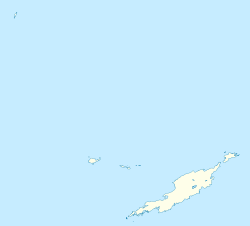
Fläche 8 km²
Einwohner (unbewohnt)

Scrub Island ist eine Insel in der Karibik und Teil des britischen Überseegebietes Anguilla. Die Insel ist mit etwas über 8 km² Fläche die größte Nebeninsel Anguillas und liegt vor der nordöstlichen Spitze der Hauptinsel. Der Meeresarm zwischen beiden Inseln ist etwa 600 m breit.

Die Ausdehnung von Scrub Island in Südwest-Nordost-Richtung beträgt dreieinhalb Kilometer bei einer maximalen Breite von etwas über einem Kilometer. Die Insel besitzt einige Sandstrände und ansonsten felsige Küsten – vor allem die Nordostspitze ist stärker zerklüftet. Dort befinden sich unmittelbar vor Scrub Island einige winzige Cays, deren größtes Eiland den Namen Deadman’s Cay trägt. Die etwas größere Nachbarinsel Little Scrub Island liegt dagegen nordwestlich.

Scrub Island ist sanft hügelig und großteils von Gestrüpp (engl. Scrub) bedeckt. Im Nordosten findet man die Reste einer Landepiste und eines Ferienressorts. Dieses Anlage war Tarnung für Drogenhändler und 1983 Schauplatz einer Razzia der amerikanischen Drogenbekämpfungsbehörde DEA [1]. Die Insel ist nun unbewohnt und nur mehr von einigen Ziegen bevölkert.

Einzelnachweise

  1. Simon Winchester: Outposts: Journeys to the Surviving Relics of the British Empire. 2004. ISBN 0-06-059861-1

Weblinks


Wikimedia Foundation.

Игры ⚽ Нужно решить контрольную?

Schlagen Sie auch in anderen Wörterbüchern nach:

  • Scrub Island — ist der Name mehrerer Inseln im britischen Überseegebiet: Scrub Island (Anguilla) Scrub Island (Britische Jungferninseln) in den Vereinigten Staaten: Scrub Island (Lake County, Florida) Scrub Island (Osceola County, Florida) Scrub Island (Glynn… …   Deutsch Wikipedia

  • Scrub Island — lying off the eastern tip of Anguilla covers an area of about three square miles (8km²). It is most easily reached by hired boat and features two excellent beaches, including the rarely visited Deadman s Cay. Privately owned, the remains of an… …   Wikipedia

  • Scrub Island — Île Scrub Île Scrub Scrub Island (en) Géographie Pays  Royaume Uni …   Wikipédia en Français

  • Anguilla — Anguilla …   Deutsch Wikipedia

  • Anguilla — This article is about the Caribbean British overseas territory. For other uses, see Anguilla (disambiguation). Anguilla …   Wikipedia

  • Anguilla — /ang gwil euh/, n. an island in the N Leeward Islands, in the E West Indies; a British dependency. 6500; 34 sq. mi. (88 sq. km). Cf. St. Kitts Nevis Anguilla. * * * Anguilla Introduction Anguilla Background: Colonized by English settlers from… …   Universalium

  • Anguilla — <p></p> <p></p> Introduction ::Anguilla <p></p> Background: <p></p> Colonized by English settlers from Saint Kitts in 1650, Anguilla was administered by Great Britain until the early 19th century,… …   The World Factbook

  • Geography of Anguilla — This article describes the geography of Anguilla. Anguilla Continent North America Subregion …   Wikipedia

  • Île Scrub — Scrub Island (en) Vue sur une plage de Scrub Island Géographie …   Wikipédia en Français

  • Géographie d'Anguilla — Continent Amérique Région Antilles Coordonnées …   Wikipédia en Français

Share the article and excerpts

Direct link
Do a right-click on the link above
and select “Copy Link”