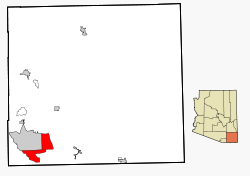
Sierra Vista Southeast — Sierra Vista Southeast, AZ U.S. Census Designated Place in Arizona Population (2000): 14348 Housing Units (2000): 5857 Land area (2000): 112.259278 sq. miles (290.750183 sq. km) Water area (2000): 0.000000 sq. miles (0.000000 sq. km) Total area… … StarDict's U.S. Gazetteer Places
Sierra Vista Southeast, AZ — U.S. Census Designated Place in Arizona Population (2000): 14348 Housing Units (2000): 5857 Land area (2000): 112.259278 sq. miles (290.750183 sq. km) Water area (2000): 0.000000 sq. miles (0.000000 sq. km) Total area (2000): 112.259278 sq. miles … StarDict's U.S. Gazetteer Places
Sierra Vista Southeast — Original name in latin Sierra Vista Southeast Name in other language State code US Continent/City America/Phoenix longitude 31.45385 latitude 110.21637 altitude 1386 Population 14797 Date 2011 05 14 … Cities with a population over 1000 database
Sierra Vista Southeast (Arizona) — Sierra Vista Southeast Lugar designado por el censo de los Estados Unidos … Wikipedia Español
Sierra Vista Southeast, Arizona — Infobox Settlement official name = Sierra Vista Southeast, Arizona settlement type = CDP imagesize = image caption = imagesize = image caption = mapsize = 250px map caption = Location in Cochise County and the state of Arizona mapsize1 = map… … Wikipedia
Sierra Vista, Arizona — Infobox Settlement official name = City of Sierra Vista, Arizona settlement type = City imagesize = image caption = image mapsize = 250x250px map caption = Location in Cochise County and the state of Arizona mapsize1 = map caption1 = subdivision… … Wikipedia
Sierra Vista — a town in S Arizona. 25,968. * * * ▪ Arizona, United States city, Cochise County, southeastern Arizona, U.S. Located 70 miles (113 km) southeast of Tucson, Sierra Vista is the county s commercial and residential centre. At first a hamlet… … Universalium
Sierra de Guadarrama — Sub Range Peaks of La Pedriza … Wikipedia
Sierra Nevada — /see er euh neuh vad euh, vah deuh/; for 2 also Sp. /syerdd rddah ne vah dhah/. 1. a mountain range in E California. Highest peak, Mt. Whitney, 14,495 ft. (4420 m). 2. a mountain range in S Spain. Highest peak, Mulhacén, 11,420 ft. (3480 m). * *… … Universalium
Plains and Sierra Miwok — People A Sierra Miwok cedar bark umuucha cabin reproduction in Yosemite Valley. The material came from lumbering operations of 19th century miners. Previously the Miwok lived in rounded huts made of brush and mud[1] … Wikipedia

