- Sitkinak
-
Trinity Islands Gewässer Pazifischer Ozean Archipel Kodiak-Archipel Anzahl der Inseln 3 Hauptinsel Tugidak Island und Sitkinak Island Gesamtfläche 408,65 km² Einwohner 2 Geographische Lage 56° 31′ N, 154° 36′ W56.519722-154.607778Koordinaten: 56° 31′ N, 154° 36′ W 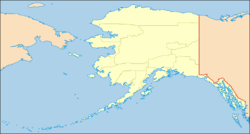

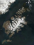 Satellitenfoto des Kodiak Archipels. Unten links Tugidak und Sitkinak.
Die Trinity Islands sind eine kleine Inselgruppe südwestlich der Insel Kodiak in Alaska, USA. Sie gehören zum Kodiak-Archipel und bestehen hauptsächlich aus den beiden Inseln Tugidak Island und Sitkinak Island. Die dritte Insel der Gruppe ist der 'Dry Rock'. Verwaltet werden die Trinity Islands durch den Kodiak Island Borough.
Inhaltsverzeichnis
Tugidak Island
Tugidak Island (56° 31′ N, 154° 36′ W56.519722222222-154.60777777778) liegt westlich von Sitkinak und ist 173,14 km² groß. Auf der Insel leben 2 Personen (Stand: 2000)[1]. Das markanteste an dieser Insel ist die unter Naturschutz stehende große seichte Lagune im Nordosten. Die Insel ist eine wichtige Brutstätte für Seehunde sowie für viele Arten von Meeresvögeln.
Sitkinak Island
Sitkinak Island (56° 33′ N, 154° 10′ W56.551944444444-154.17083333333) ist die östliche Insel der Gruppe. Sie ist 235,51 km² groß und unbewohnt[2]. Auch Sitkinak besitzt eine große Lagune, welche etwa in der Inselmitte liegt.
Einzelnachweise
- ↑ Tugidak Island: Block 1018, Census Tract 1, Kodiak Island Borough, Alaska United States Census Bureau
- ↑ Sitkinak Island: Block 1019, Census Tract 1, Kodiak Island Borough, Alaska United States Census Bureau
Weblinks
- Tugidak Island Critical Habitat Area Alaska Department of Fish and Game
- USGS GNIS: Trinity Islands
Inseln und Inselgruppen des Kodiak-ArchipelsAfognak Island | Aghik Island | Aghiyuk Island | Aiaktalik Island | Aliksemit Island | Anowiki Island | Ban Island | Barren Islands | Chowiet Island | Dark Island | Dry Rock | East Amatuli Island | Geese Islands | Kateekuk Island | Kiliktagik Island | Kodiak-Insel | Marmot Island | Nord Island | Raspberry Island | Semidi Islands | Shuyak Island | Sitkalidak Island | Sitkinak Island | South Island | Spruce Island | Sud Island | Sugarloaf Island | Suklik Island | Sundstrom Island | Trinity Islands | Tschirikow-Insel | Tugidak Island | Twoheaded Island | Ugak Island | Uganik Island | Ushagat Island | West Amatuli Island | Whale Island | Woody Island


Wikimedia Foundation.