Snowy River Shire

Snowy River Shire
Shire of Snowy River
Australia-Map-NSW-LGA-SnowyRiver.png
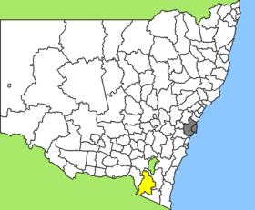
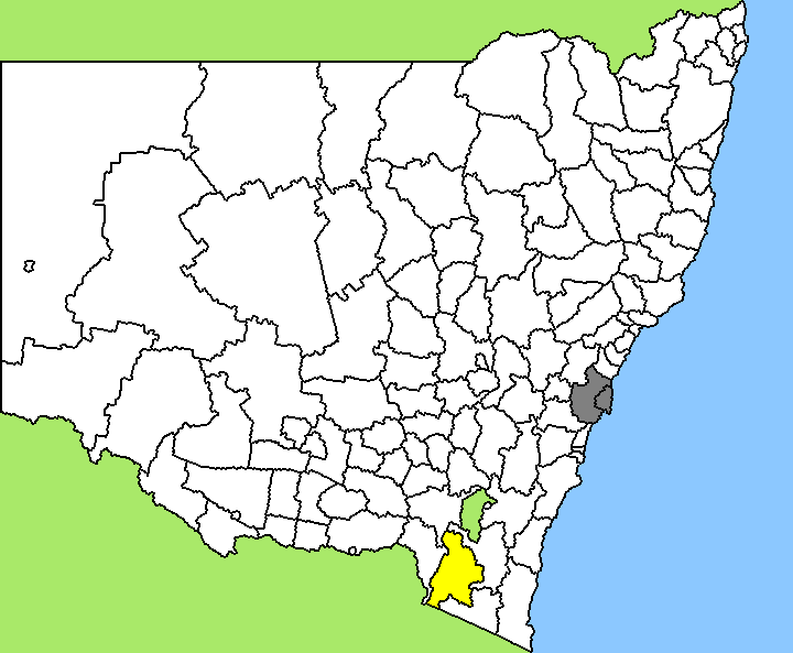
Lage des Snowy River Shire in New South Wales
Gliederung
Staat: Australien Australien
Bundesstaat: Flag of New South Wales.svg New South Wales
Verwaltungssitz: Berridale
Daten und Zahlen
Fläche: 6.030 km²
Einwohner: 7.186 (2006) [1]
Bevölkerungsdichte: 1,2 Einwohner je km²
-36.366666666667148.83333333333

Snowy River Shire ist ein lokales Verwaltungsgebiet (LGA) im australischen Bundesstaat New South Wales. Das Gebiet ist 6.030 km² groß und hat etwa 7.600 Einwohner.

Snowy River liegt im Südosten des Staates an der Grenze zu Victoria etwa 150 km südlich der australischen Hauptstadt Canberra. Das Gebiet umfasst 83 Ortsteile und Ortschaften, darunter Old Adaminaby, Anglers Reach, Berridale, Blue Cow, Dalgety, Eucumbene, Guthega, Ingebyra, Jimenbuen, Jindabyne, Kiandra, Numbla Vale, Perisher Valley, Smiggin Holes und Thredbo sowie Teile von Adaminaby und Cooma. Der Sitz des Shire Councils befindet sich in der Ortschaft Berridale im Zentrum der LGA, die etwa 850 Einwohner hat.

Verwaltung

Der Snowy River Shire Council hat neun Mitglieder, die von den Bewohnern der LGA gewählt werden. Snowy River ist nicht in Bezirke untergliedert. Aus dem Kreis der Councillor rekrutiert sich auch der Mayor (Bürgermeister) des Councils.

Weblinks

Einzelnachweise

  1. Australian Bureau of Statistics (25. Oktober 2007): Snowy River (A) (Local Government Area) (Englisch). 2006 Census QuickStats. Abgerufen am 6. April 2010.

Wikimedia Foundation.

Игры ⚽ Поможем написать реферат

Schlagen Sie auch in anderen Wörterbüchern nach:

  • Snowy River Shire Council — Infobox Australian Place | type = lga name = Snowy River Shire caption = Location in New South Wales state=New South Wales region=Monaro area=6030 est = seat=Berridale (2 Myack Street)cite web title=Snowy River Shire Council publisher =… …   Wikipedia

  • Snowy River — Geobox | River name = Snowy other name = other name1 = other name2 = other name3 = other name4 = other name5 = category = image caption = The Snowy River below McKillops Bridge etymology = nickname = The Snowy country = Australia country1 =… …   Wikipedia

  • Snowy-Mountains-System — Talbingo Stausee …   Deutsch Wikipedia

  • Snowy Mountains Scheme — The Snowy Mountains Scheme is a hydroelectricity and irrigation complex in south east Australia. The waters of the Snowy River and its tributary, the Eucumbene, are captured at high elevations and diverted inland to the Murray River and the… …   Wikipedia

  • Shire of Orbost — Infobox Australian Place | type = lga name = Shire of Orbost state = vic region = area = 9347 est = 1892 seat = Orbost pop = 6730 (1992) [cite book|title=Victorian Year Book|author=Australian Bureau of Statistics, Victoria… …   Wikipedia

  • Shire of Tambo — Infobox Australian Place | type = lga name = Shire of Tambo state = vic region = area = 3506.86 est = 1882 seat = Lakes Entrance pop = 10720 (1992) [cite book|title=Victorian Year Book|author=Australian Bureau of Statistics, Victoria… …   Wikipedia

  • Public Fight to Stop the Sale of Snowy Hydro — The public fight to stop the sale of the Snowy Hydro commenced from November 2005 when a band of notable public, other persons banded together to try and stop its privatisation.The group who first joined together in an attempt to stop the sell… …   Wikipedia

  • Wakool Shire — Shire of Wakool New South Wales Location in New South Wales Population: 4,427(2009) …   Wikipedia

  • Cooma-Monaro Shire — Cooma Monaro New South Wales Location in New South Wales Population …   Wikipedia

  • Tumbarumba Shire Council — Infobox Australian Place | type = lga name = Tumbarumba Shire caption = Location in New South Wales state=New South Wales region=Riverina area=4392 area footnotes = cite web title=Tumbarumba Shire Council publisher = Department of Local… …   Wikipedia

Share the article and excerpts

Direct link
Do a right-click on the link above
and select “Copy Link”