- South Molle Island
-
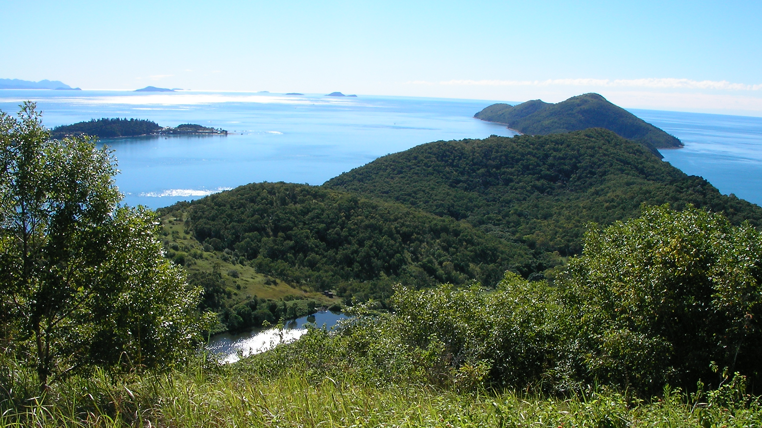
South Molle Island Blick von Süden nach Norden
Gewässer Korallenmeer Inselgruppe Whitsunday Islands Geographische Lage 20° 16′ 8,59″ S, 148° 50′ 15,19″ O-20.269053148.837552Koordinaten: 20° 16′ 8,59″ S, 148° 50′ 15,19″ O 

South Molle Island ist eine Insel in der Great Barrier Reef World Heritage Area. Die Insel gehört zu einer Untergruppe der Pfingstsonntagsinseln (Whitsunday Islands), den sieben Inseln umfassenden Molle Islands. Diese werden offiziell zu den Cumberland Islands gezählt.
Inhaltsverzeichnis
Beschreibung
South Molle Island gehört zu den 17 Inseln der 74 umfassenden Inselgruppe der Whitesunday Inslands, die bewohnt ist und auch ein Hotel Resort besitzt. Sie liegt unmittelbar vor der australischen Küste und kann von dem nahegelegenen Shute Harbour mit Schiffen oder mit auf Wasser landenden Flugzeugen erreicht werden. Der nächstgelegende Ort ist Airlie Beach.
South Molle Island wurde in einer Eiszeit als Insel ausgebildet als das Polareis schmolz. Benannt ist sie nach dem Oberst George James Molle, der in der britischen Kolonialzeit Lieutenant Governor in New South Wales war. Vor der europäischen Besiedlung lebten in diesem Inselgebiet die Ngaro 9000 Jahre land, ein Stamm der Aborigines, die nomadisch auf den Inseln lebten und dort fischten und jagten. Nach Konflikten mit den europäischen Kolonialisten ging dieser Stamm unter. Auf South Mole Island stellten sie ihre Steinwerkzeuge her.[1]
Vor der Insel in Richtung Whitsuday Island befinden sich die kleinen unbewohnten Inseln Goat Island (Ziegeninsel), Denman Island und Planton Island. In unmittelbarer Nähe befindet sich zwei weitere Touristeninseln, Daydream Island und Long Island. Von der Bauer Bay sind die kleine unbewohnte Mid Molle Island und die größere North Molle Island zu sehen. Vor der Bauer Bay können Flugzeuge wassern.
Touristische Informationen
South Molle Island zählt zum South Molle Nationalpark. Es gibt mehrere Buchten und Strände: Oyster Bay, Turtel Bay, Pine Bay, Woddy Bay, Sandy Bay und Bauer Bay. Auf der Insel kann zu dem in Mitte der Insel befindlichen Süßwassersee und die Hügel Spion Kop, The Horn, Mount Jeffreys und Lamond Hill gewandert werden. Bei Ebbe ist von South Molle Island Goat Island zu Fuß erreichbar. Das South Molle Island Resort auf der Insel hat über 200 Zimmer und einen Golfplatz mit 9 Löchern.[2]
Weblinks
 Commons: South Molle Island – Sammlung von Bildern, Videos und Audiodateien
- Flora und Fauna auf South Molle Island
- Detaillierte Lagekarte der Whitsunday Islands mit South Molle Island
Einzelnachweise
- ↑ Geschichte der South Molle Island auf southmolleisland.com.au, abgerufen am 23. Mai 2010
- ↑ Informationen auf islandofaustralia.com, abgerufen am 22. Mai 2010
Kategorien:- Insel (Australien und Ozeanien)
- Insel (Korallenmeer)
- Insel (Queensland)
Wikimedia Foundation.