South Shropshire

South Shropshire
South Shropshire District
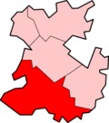
South Shropshire
Lage in Shropshire
Status District
Region West Midlands
Verw.grafschaft Shropshire
Verwaltungssitz Ludlow
Fläche 1027,26 km² (23.)
Einwohner 42.500 (346.)
ONS-Code 39UF
Website -
Gründung 1974
Auflösung 2009

South Shropshire war ein District in der Grafschaft Shropshire in England. Verwaltungssitz war die Stadt Ludlow. Der District umfasste auch die Orte Bishop's Castle, Church Stretton, Cleobury Mortimer und Craven Arms.

Der Bezirk wurde am 1. April 1974 gebildet und entstand aus der Fusion der Rural Districts Clun and Bishop's Castle und Ludlow. Am 1. April 2009 wurde er aufgrund einer Gebiets- und Verwaltungsreform aufgelöst und ging in der neuen Unitary Authority Shropshire auf.


Wikimedia Foundation.

Игры ⚽ Поможем сделать НИР

Schlagen Sie auch in anderen Wörterbüchern nach:

  • South Shropshire — is a local government district in south west Shropshire, England. South Shropshire is the most rural district of one of the UK s most rural counties, the population of the district is 40,000 spread out over 1,027 km² of forest, mountains,… …   Wikipedia

  • South Shropshire — ▪ district, England, United Kingdom       district, administrative county of Shropshire, western England. Nearly all of the district lies in the historic county of Shropshire, but a small area south of Ludlow is part of the historic county of… …   Universalium

  • South Shropshire local elections — South Shropshire Council is elected every four years.Political controlIndependent 1973 2002No overall control 2002 2007Conservative 2007 presentCouncil electionsSouth Shropshire Council election 1999South Shropshire Council election 2003South… …   Wikipedia

  • South Shropshire (UK Parliament constituency) — UK former constituency infobox Name = South Shropshire Type = County Year = 1832 Abolition = 1885 memners = twoSouth Shropshire is a former United Kingdom Parliamentary constituency. It was a constituency of the House of Commons of the Parliament …   Wikipedia

  • Nash, South Shropshire — Coordinates: 52°20′35″N 2°35′06″W / 52.343°N 2.585°W / 52.343; 2.585 …   Wikipedia

  • Shropshire Council — is the unitary authority which will cover most of the ceremonial county of Shropshire, in the West Midlands of England. It will be formally established on April 1, 2009, upon the abolition of the non metropolitan districts of Bridgnorth, North… …   Wikipedia

  • Shropshire (Unitary Authority) — Basisdaten Status Unitary Authority Region West Midlands …   Deutsch Wikipedia

  • Shropshire — Geografie Status Zeremonielle Grafschaft Region: West Midlands Fläche: 3.487 km² Historische Hauptstadt …   Deutsch Wikipedia

  • Shropshire — er et engelsk provins (county) i Midtengland. Det er et af Englands mest landlige områder. Den officielle provinshovedby er Shrewsbury, men Ludlow anses traditionelt for at være hovedbyen, da Ludlows borg tidligere var en kongelig residens.… …   Danske encyklopædi

  • Bicton, South Shropshire — infobox UK place country = England static static image caption= latitude= 52.73 longitude= 02.83 official name =Bicton population = shire district= shire county= Shropshire region= West Midlands constituency westminster= post town= postcode… …   Wikipedia

Share the article and excerpts

Direct link
Do a right-click on the link above
and select “Copy Link”