South Taranaki Bight

South Taranaki Bight
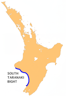
Lage der South Taranaki Bight

Die South Taranaki Bight ist eine große Bucht, die sich südlich und östlich der Küste Taranaki auf der Nordinsel Neuseelands erstreckt. Das Gegenstück dazu ist die North Taranaki Bight nördlich von Cape Egmont.

Die Größe der Bucht wird unterschiedlich angegeben. Im engen Sinne erstreckt sie sich von der Mündung des Kaupokonui Stream südlich des Taranaki bis zur Mündung des Patea River. Im weiteren Sine wird die gesamte Westküste der südlichen Teils der Nordinsel bis Waikanae an der Kapiti Coast hinzugerechnet.

-39.666666666667174.16666666667

Wikimedia Foundation.

Игры ⚽ Нужно сделать НИР?

Schlagen Sie auch in anderen Wörterbüchern nach:

  • South Taranaki Bight — The South Taranaki Bight is the name given to the large bay which extends south and east from the south coast of Taranaki in New Zealand s North Island. With more symmetry than poetry or originality, it is matched by the North Taranaki Bight to… …   Wikipedia

  • South-Taranaki-Distrikt — South Taranaki District Council Karte Basisdaten Region …   Deutsch Wikipedia

  • North Taranaki Bight — Location of North Taranaki Bight The North Taranaki Bight is the name given to the large bay which extends north and east from the north coast of Taranaki in New Zealand s North Island. The name is echoed by the South Taranaki Bight to the south… …   Wikipedia

  • North Taranaki Bight — 38.7174.25 Koordinaten: 38° 42′ 0″ S, 174° 15′ 0″ O …   Deutsch Wikipedia

  • Taranaki — is a region in the west of New Zealand s North Island and is the 10th largest region of New Zealand by population [cite web|url=http://www.stats.govt.nz/census/census outputs/quickstats/snapshotplace2.htm?id=1000007 type=region… …   Wikipedia

  • Taranaki (Region) — Taranaki Karte Basisdaten Hauptstadt …   Deutsch Wikipedia

  • Taranaki — ▪ region, New Zealand       regional council, west North Island, northern New Zealand. It is centred on the Taranaki Peninsula and extends north to the Mokau River and south and east to include the Waitotara River. Its topography is marked by… …   Universalium

  • Taranaki — 39°18′S 174°8′E / 39.3, 174.133 …   Wikipédia en Français

  • Bight (geography) — In geography, bight has two meanings. A bight can be simply a bend or curve in any geographical feature mdash;usually a bend or curve in the line between land and water. Alternatively, the term can refer to a large (and often only slightly… …   Wikipedia

  • Region Taranaki — Taranaki Karte Basisdaten Hauptstadt: Stratford …   Deutsch Wikipedia

Share the article and excerpts

Direct link
Do a right-click on the link above
and select “Copy Link”