- Staffordshire Moorlands
-
Staffordshire Moorlands District 
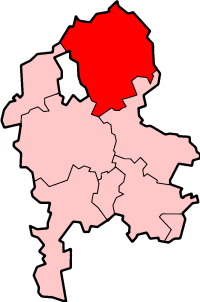
Lage in StaffordshireStatus District Region West Midlands Verw.grafschaft Staffordshire Verwaltungssitz Leek Fläche 575,85 km² (86.) Einwohner 95.400 (237.) ONS-Code 41UH Website www.staffsmoorlands.gov.uk Staffordshire Moorlands ist ein District in der Grafschaft Staffordshire in England. Verwaltungssitz ist die Stadt Leek. Weitere bedeutende Orte sind Biddulph und Cheadle. Sehenswürdigkeiten sind unter Anderem der Freizeitpark Alton Towers und der Landschaftsgarten Biddulph Grange.
Der nach einer ausgedehnten Heide (engl. moorland) benannte Bezirk wurde am 1. April 1974 gebildet und entstand aus der Fusion der Urban Districts Biddulph und Leek sowie der Rural Districts Cheadle und Leek.

Cannock Chase | East Staffordshire | Lichfield | Newcastle-under-Lyme | South Staffordshire | Stafford | Staffordshire Moorlands | Tamworth
Wikimedia Foundation.
Schlagen Sie auch in anderen Wörterbüchern nach:
Staffordshire Moorlands — is a local government district in Staffordshire, England. Its council, Staffordshire Moorlands District Council, is based in Leek and is located between the city of Stoke on Trent and the Peak District National Park. The 2001 census recorded the… … Wikipedia
Staffordshire Moorlands — Distrito del Reino Unido Ubicación en el co … Wikipedia Español
Staffordshire Moorlands — ▪ district, England, United Kingdom district, administrative and historic county of Staffordshire (Staffordshire Moorlands), central England, directly east of the city of Stoke on Trent. Staffordshire Moorlands includes part of the Peak… … Universalium
Staffordshire Moorlands local elections — Staffordshire Moorlands Council is elected every four years.Political controlNo overall control 1973 1991Independent 1991 1995No overall control 1995 2007Conservative 2007 presentCouncil electionsStaffordshire Moorlands Council election… … Wikipedia
Staffordshire Moorlands (UK Parliament constituency) — UK constituency infobox Name = Staffordshire Moorlands Map1 = StaffordshireMoorlands Map2 = Staffordshire Type = County Year = 1983 Entity = Staffordshire County = Staffordshire EP = West Midlands MP = Charlotte Atkins Party = LabourStaffordshire … Wikipedia
Staffordshire Moorlands Pan — The Staffordshire Moorlands Pan is a 2nd century AD bronze trulla depicting the forts of Hadrian s Wall, with names above. It was found in June 2003and was in 2005 bought jointly by the Tullie House Museum in Carlisle, the Potteries Museum in… … Wikipedia
Staffordshire — Geography Status Ceremonial (smaller) Non metropolitan county … Wikipedia
Moorlands Radio — Broadcast area Staffordshire Moorlands Frequency 103.7 MHz First air date 7 November 2009 … Wikipedia
Staffordshire — Geographie Status: Zeremonielle und Verwaltungsgrafschaft Region: West Midlands Fläche: 2.713 Quadratkilometer … Deutsch Wikipedia
Staffordshire — /staf euhrd shear , sheuhr/, n. a county in central England. 988,400; 1154 sq. mi. (2715 sq. km). Co. seat: Stafford. Also called Stafford, Staffs /stafs/. * * * Administrative (pop., 2001: 806,737), geographic, and historic county, west central… … Universalium
Staffordshire Moorlands
18+
© Academic, 2000-2025
- Kontaktieren Sie uns: Unterstützung, Werbung
Wörterbücher Export, schritte mit PHP, Joomla, Drupal, WordPress, MODx.