- Strathfield Municipality
-
Municipality of Strathfield 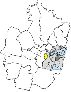
Lage der Strathfield Municipality in SydneyGliederung Staat:  Australien
Bundesstaat:  New South Wales
Verwaltungssitz: Strathfield Daten und Zahlen Fläche: 14 km² Einwohner: 31.983 (2006) [1] Bevölkerungsdichte: 2.285 Einwohner je km² -33.866666666667151.1Koordinaten: 33° 52′ S, 151° 6′ ODie Municipality of Strathfield ist ein lokales Verwaltungsgebiet (LGA) im australischen Bundesstaat New South Wales. Strathfield gehört zur Metropole Sydney, der Hauptstadt von New South Wales. Das Gebiet ist 14 km² groß und hat etwa 32.000 Einwohner.
Strathfield liegt am Westende von Inner Sydney etwa 11 km westlich des Stadtzentrums. Das Gebiet beinhaltet 13 Stadtteile: Flemington, Flemington Markets, Homebush South, Homebush West, Strathfield West und Teile von Belfield, Enfield, Enfield South, Greenacre, Homebush, Strathfield, North Strathfield und Strathfield South. Der Verwaltungssitz des Councils befindet sich im Stadtteil Strathfield im Zentrum der LGA.
Verwaltung
Der Strathfield Municipal Council hat neun Mitglieder, die von den Bewohnern der LGA gewählt werden. Strathfield ist nicht in Bezirke untergliedert. Aus dem Kreis der Councillor rekrutiert sich auch der Mayor (Bürgermeister) des Councils.
Weblinks
Einzelnachweise
- ↑ Australian Bureau of Statistics (25. Oktober 2007): Strathfield (A) (Local Government Area) (Englisch). 2006 Census QuickStats. Abgerufen am 6. April 2010.
Kategorien:- Local Government Area in New South Wales
- Local Government Area in Sydney

Wikimedia Foundation.