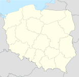
Szarbia

Szarbia
Szarbia
Coats of arms of None.svg
Szarbia (Polen)
Szarbia
Szarbia
Basisdaten
Staat: Polen
Woiwodschaft: Kleinpolen
Landkreis: Proszowicki
Gmina: Koniusza
Geographische Lage: 50° 8′ N, 20° 15′ O50.13611111111120.256111111111Koordinaten: 50° 8′ 10″ N, 20° 15′ 22″ O
Höhe: 239 m n.p.m
Einwohner:
Postleitzahl: 32-104
Telefonvorwahl: (+48) 12
Kfz-Kennzeichen: KPR

Szarbia ist ein Dorf in der Gemeinde Koniusza im Powiat Proszowicki. Es liegt auf einer Höhe von etwa 239 Metern über dem Meeresspiegel in der Woiwodschaft Kleinpolen in Polen. Die naheliegendsten Nachbarorte im zwei Kilometerradius sind in südlicher Richtung das Dorf Glew, in westlicher Richtung Glewiec, in nordöstlicher Richtung Karwin und in südöstlicher Richtung Żudów. Das Verwaltungszentrum der Gemeinde liegt in Koniusza etwa acht Kilometer in nördlicher Richtung von Szarbia entfernt. Haupteinnahmequelle des Dorfes ist die Landwirtschaft.

In Szarbia fand man bei Ausgrabungen 1997 bis 1999 Dutzende Gräber und Überreste von frühen Siedlungen aus dem Neolithikum und der Frühbronzezeit.

Quelle


Wikimedia Foundation.

Игры ⚽ Нужно решить контрольную?

Schlagen Sie auch in anderen Wörterbüchern nach:

  • Szarbia — Infobox Settlement name = Szarbia settlement type = Village total type = image shield = subdivision type = Country subdivision name = POL subdivision type1 = Voivodeship subdivision name1 = Lesser Poland subdivision type2 = County subdivision… …   Wikipedia

  • Szarbia Zwierzyniecka — Szarbia Zwierzyniecka …   Deutsch Wikipedia

  • Szarbia Zwierzyniecka — Infobox Settlement name = Szarbia Zwierzyniecka settlement type = Village total type = image shield = subdivision type = Country subdivision name = POL subdivision type1 = Voivodeship subdivision name1 = Świętokrzyskie subdivision type2 = County… …   Wikipedia

  • Gmina Koniusza — Infobox Settlement name = Gmina Koniusza other name = Koniusza Commune settlement type = Gmina total type = Total image shield = POL gmina Koniusza COA.svg subdivision type = Country subdivision name = POL subdivision type1 = Voivodeship… …   Wikipedia

  • Gmina Skalbmierz — Infobox Settlement name = Gmina Skalbmierz other name = Skalbmierz Commune settlement type = Gmina total type = Total image shield = POL Skalbmierz COA.svg subdivision type = Country subdivision name = POL subdivision type1 = Voivodeship… …   Wikipedia

  • Chorążyce, Lesser Poland Voivodeship — See also: Chorążyce, Podlaskie Voivodeship Chorążyce   Village   …   Wikipedia

  • Czernichów, Proszowice County — For other places with the same name, see Czernichów. Czernichów   Village   Country  Poland Voivode …   Wikipedia

  • Dalewice —   Village   …   Wikipedia

  • Górka Jaklińska —   Village   …   Wikipedia

  • Muniaczkowice —   Village   …   Wikipedia

Share the article and excerpts

Direct link
Do a right-click on the link above
and select “Copy Link”