- Texas Panhandle
-

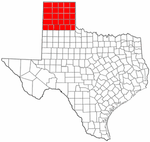
Der Texas Panhandle (wörtlich: Texas-Pfannenstiel) ist eine Region des US-amerikanischen Staates Texas, bestehend aus den 26 nördlichsten Countys.
Der Panhandle ist ein rechteckiges Areal, das im Westen an den Bundesstaat New Mexico sowie im Norden und Osten an den Bundesstaat Oklahoma grenzt. Im Süden gilt das Swisher County als Grenze. Die Fläche beträgt 66.883,58 km² oder 9,864 % der Gesamtfläche von Texas und zusätzlich 162,53 km² von Wasser bedeckter Fläche. Laut der Volkszählung im Jahr 2000 betrug die Bevölkerung 402.862 Einwohner oder 1,93 % der Gesamtbevölkerung des Staates. Bemerkenswerterweise ist der Panhandle nicht gleichbedeutend mit North Texas, das mehr im Südosten liegt.
Die westliche Hälfte, westlich der Caprock Klippen und nord- und südlich des Canadian River Bruchs, ist ziemlich flaches Gelände. Die größte Stadt im Panhandle ist Amarillo. Dieses relativ flache Land mündet in Palo Duro Canyon südöstlich der Stadt, dem zweitgrößten Canyon der USA.
Da das Aufnahmegesetz dem Staat Texas erlaubt, sich selbst aufzuteilen, wurde 1915 ein Gesetz über die Gründung eines Staates Jefferson in den Kongress eingebracht, der gleichbedeutend mit dem Texas Panhandle sein sollte. Die Gesetzesinitiative fand aber keine Mehrheit
Aus politischer Sicht gehört diese Region zu den konservativsten der gesamten Vereinigten Staaten.
Countys
- Armstrong County
- Briscoe County
- Carson County
- Castro County
- Childress County
- Collingsworth County
- Dallam County
- Deaf Smith County
- Donley County
- Gray County
- Hall County
- Hansford County
- Hartley County
- Hemphill County
- Hutchinson County
- Lipscomb County
- Moore County
- Ochiltree County
- Oldham County
- Parmer County
- Potter County
- Randall County
- Roberts County
- Sherman County
- Swisher County
- Wheeler County
Bekannte Städte
Weblinks
Kategorie:- Geographie (Texas)
Wikimedia Foundation.