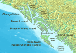
- Baranof Island
-
Baranof Island Gewässer Pazifischer Ozean Inselgruppe Alexanderarchipel Geographische Lage 56° 59′ N, 134° 58′ W56.982777777778-134.964722222221643Koordinaten: 56° 59′ N, 134° 58′ W Länge 160 km Breite 48 km Fläche 4.160 km² Höchste Erhebung Veniaminof Peak
1.643 mEinwohner 8.532 (2000)
2,1 Einw./km²Hauptort Sitka Baranof Island, auch Baranov Island oder Sitka Island genannt, ist eine Insel im Alexander-Archipel im Alaska Panhandle im Südosten Alaskas. Von den einheimischen Tlingit wurde sie Sheet’-ká X'áat'l (oft einfach „Shee“) genannt. Sie gehört zu den ABC-Inseln von Alaska.
Inhaltsverzeichnis
Geographie
Die Insel ist maximal 160 km lang und rund 50 km breit. Sie ist die gebirgigste Insel des Alexander-Archipels und erreicht im Veniaminof Peak eine Höhe von 1643 m über dem Meer.[1] Mit einer Fläche von 4100 km² ist sie die achtgrößte Insel Alaskas und die zehntgrößte Insel der USA; in der Liste der größten Inseln der Welt liegt sie auf Rang 135. Die Bevölkerung der Insel betrug im Jahr 2000 8532 Personen.
Fast die ganze Fläche der Insel ist Teil der Stadt und des Boroughs von Sitka (Sitka dehnt sich nach Norden auch auf Chichagof Island aus). Der einzige Teil von Baranof Island, der nicht zu Sitka gehört, ist ein kleiner Streifen Land (9,75 km²) im äußersten Südosten, das zum Petersburg Census Area gehört und die Stadt Port Alexander einschließt. Dieser Teil hatte im Jahr 2000 eine Bevölkerung von 81 Personen. Die Städte Baranof Warm Springs, Port Armstrong und Port Walter liegen auf der östlichen Seite der Insel. Goddard, eine aufgegebene Siedlung 25 km südlich von Sitka, hat einige Privathäuser und heiße Quellen mit zwei öffentlichen Badeanstalten. Es gibt drei Lachs-Aufzuchtstationen, eine unmittelbar nördlich von Port Alexander bei Port Armstrong, eine andere unmittelbar nördlich von Baranof Warm Springs bei Hidden Falls, und die dritte südlich von Sitka in der Nähe des Medvejie Lake.
Fischfang, -verarbeitung und Tourismus sind wichtige Industrien auf der Insel, die auch bekannt ist für Braunbären und Sitka-Schwarzwedelhirsche (Odocoileus hemionus sitkensis), einer Unterart des Maultierhirsches (Odocoileus hemionus).
Geschichte
Die erste europäische Siedlung auf der Insel wurde 1799 von Alexander Baranow, dem Direktor und ersten Gouverneur der Russisch-Amerikanische Kompagnie, gegründet, nach dem die Insel und der Archipel benannt sind. Nach der Schlacht von Sitka 1804 war Baranof Island das Zentrum der russischen Aktivitäten in Nordamerika im Zeitraum bis 1867 und das Hauptquartier für die russischen Pelzhandelsinteressen.
Um 1900 entstanden, zentriert um Sitka und auf der Nordseite der Insel um die Rodman Bay, Konservenfabriken, Walfangstationen und Fuchsfarmen. Die meisten wurden zu Beginn des Zweiten Weltkriegs aufgegeben. Die Überbleibsel dieser Vorposten bestehen noch, wenn auch in verfallenem Zustand.
Weblinks
- Tlingit Geographical Place Names for the Sheet’Ka Kwaan — Sitka Tribe of Alaska, eine interaktive Karte der Sitka Area mit einheimischen Bezeichnungen.
Einzelnachweise
- ↑ Veniaminof Peak bei peakbagger.com (english)
Inseln im AlexanderarchipelAdmiralty Island | Annette Island | Baranof Island | Chichagof Island | Dall Island | Etolin Island | Kuiu Island | Kupreanof Island | Prince-of-Wales-Insel | Revillagigedo Island | Wrangell Island
Wikimedia Foundation.
Schlagen Sie auch in anderen Wörterbüchern nach:
Baranof Island — Infobox Islands name = Baranof image caption = Islands of the Pacific Northwest Coast image size = locator Location map|Alaska|lat=57.0|long= 135.0 map custom = yes native name = native name link = nickname = location = ABC islands of Alaska… … Wikipedia
Baranof Island — Sp Barãnovo salà Ap Baranof Island Sp Bãranofo salà Ap Baranof Island L Aleksandro ss., JAV (Aliaska) … Pasaulio vietovardžiai. Internetinė duomenų bazė
List of geographic features on Baranof Island — The following is a partial list of geographic features on Baranof Island:Lakes*Baranof Lake *Blue Lake *Camp Lake *Green Lake *Indigo Lake *Medvejie Lake *Swan LakeMountains*Peak 5390 *Mount Arrowhead *Mount Bassie *Mount Furuhelm *Mount… … Wikipedia
Baranof Warm Springs, Alaska — Baranof Warm Springs is a small, primarily seasonally occupied community in the U.S. state of Alaska, located on the eastern side of Baranof Island in the Alexander Archipelago. It is occasionally referred to simply as Baranof . Baranof Warm… … Wikipedia
Baranof River — is a glacially fed river on the eastern side of Baranof Island, in the Alexander Archipelago, in the Alaska Panhandle. The source of the river is from the unnamed icefields surrounding Peak 5390. Baranof River feeds into Baranof Lake, and the… … Wikipedia
Baranof Cross-Island Trail — Infobox Hiking trail Name=Baranof Cross Island Trail Photo=Bassie Icefield Late Summer.jpg Caption=A group of two crossing the icefield on Mt. Bassie. Location=Baranof Island, Alaska, United States Length=16 mi; 25 km Start/End Points=Sitka, AK;… … Wikipedia
Baranof Lake — Infobox lake lake name = Baranof Lake image lake = Baranof Lake.jpg caption lake = A view southeast of the east half of Baranof Lake and part of Warm Springs Bay image bathymetry = caption bathymetry = location = Baranof Island, Sitka City and… … Wikipedia
Baranof Warm Springs (Alaska) — Baranof Warm Springs est une localité d Alaska aux États Unis situé à l est de l Île Baranof, dans l Archipel Alexandre du Passage Intérieur, Borough de Sitka à 57°05′22″N 134°49′59″O / … Wikipédia en Français
Baranof — [bar′ə nôf΄] 〚after A. A. Baranof, 1st gov. of the Russ colonies in America〛 island in Alexander Archipelago, Alas.: c. 1,600 sq mi (4,144 sq km): largest city, Sitka * * * … Universalium
Baranof — [bar′ə nôf΄] [after A. A. Baranof, 1st gov. of the Russ colonies in America] island in Alexander Archipelago, Alas.: c. 1,600 sq mi (4,144 sq km): largest city, Sitka … English World dictionary


