Trinity Peninsula

Trinity Peninsula
Trinity Peninsula
Landkarte der Antarktischen Halbinsel, mit der Trinity Peninsula rot markiert
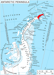
Gewässer 1 Weddellmeer
Gewässer 2 Antarctic Sound, Bransfieldstraße

Geographische Lage

63° 37′ 0″ S, 58° 20′ 0″ W-63.616666666667-58.333333333333Koordinaten: 63° 37′ 0″ S, 58° 20′ 0″ W
Trinity Peninsula (Antarktische Halbinsel)
Trinity Peninsula
Länge 130 km

Die Trinity Peninsula (deutsch „Dreifaltigkeits-Halbinsel“) ist der äußerste nordöstliche Ausläufer der Antarktischen Halbinsel, und damit ein Teil Grahamlands, und erstreckt sich ungefähr 130 Kilometer weit in nordöstlicher Richtung. Seit mehr als einem Jahrhundert werden von Kartographen unterschiedliche Namen wie Trinity, Palmer oder Louis Philippe benutzt, von denen jede eine historische Würdigung beinhaltet. Der empfohlene Name kommt vom Trinity Land, wie Edward Bransfield die Gegend im Januar 1820 taufte, auch wenn die genaue Anwendung nicht bekannt ist und unter Antarktishistorikern umstritten ist.


Wikimedia Foundation.

Игры ⚽ Поможем решить контрольную работу

Schlagen Sie auch in anderen Wörterbüchern nach:

  • Trinity Peninsula — ) is the extreme northeast portion of the Antarctic Peninsula, extending northeastward for about 130 km (80 miles) from a line connecting Cape Kater and Cape Longing. Dating back more than a century, chartmakers used various names (Trinity,… …   Wikipedia

  • Trinity (disambiguation) — Trinity, in its general sense, can refer to any collection of three things. More specifically, it refers to:Religion*Trinity, the Christian concept of God as three persons *Trinity Sunday in Christian liturgy *Trimurti, the Hindu concept of God… …   Wikipedia

  • Península Trinidad — Localización de la península Trinidad. La península Trinidad o península Luis Felipe es el nombre dado al extremo norte de la península Antártica. Se extiende hacia el noreste por cerca de 130 km desde la línea que conecta el cabo Kjellman ( …   Wikipedia Español

  • Trinity County, California — County of Trinity   County   Seal …   Wikipedia

  • Cockerell Peninsula — (63°24′S 58°8′W / 63.4°S 58.133°W / 63.4; 58.133) is an ice covered, bulb shaped peninsula between Lafond Bay and Huon Bay on the north coast of Trinity Peninsula. It was discover …   Wikipedia

  • Antarctic Peninsula — map. Location o …   Wikipedia

  • Tabarin Peninsula — (coord|63|32|S|57|0|W|) is a peninsula 15 nautical miles (28 km) long and 5 to 12 nautical miles (22 km) wide, lying south of the trough between Hope Bay and Duse Bay and forming the east extremity of Trinity Peninsula. Discovered and charted by… …   Wikipedia

  • Bonavista Peninsula — The Bonavista Peninsula is a large peninsula on the east coast of the island of Newfoundland in the Canadian province of Newfoundland and Labrador.The peninsula runs 85 km northeast from a 19 km wide isthmus and measures between 15 40 km in width …   Wikipedia

  • Smith Sound (Trinity Bay, Newfoundland and Labrador) — Smith Sound is a zigzag 24 kilometer inner region of Trinity Bay. This sound is one of the longest portions of inshore waterways in Newfoundland, located on its north eastern coast in the Canadian province of Newfoundland and Labrador. Bonavista… …   Wikipedia

  • Avalon Peninsula — a peninsula in SE Newfoundland, in E Canada: surrounded on three sides by the Atlantic Ocean. ab. 3579 sq. mi. (9270 sq. km). * * * ▪ peninsula, Newfoundland, Canada  peninsula in southeastern Newfoundland, Canada; it is joined to the main part… …   Universalium

Share the article and excerpts

Direct link
Do a right-click on the link above
and select “Copy Link”