Tumut Shire

Tumut Shire
Shire of Tumut
Australia-Map-NSW-LGA-Tumut.png
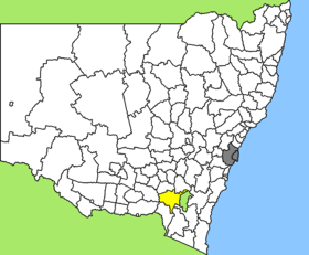
Lage des Tumut Shire in New South Wales
Gliederung
Staat: Australien Australien
Bundesstaat: Flag of New South Wales.svg New South Wales
Verwaltungssitz: Tumut
Daten und Zahlen
Fläche: 4.566 km²
Einwohner: 10.801 (2006) [1]
Bevölkerungsdichte: 2,4 Einwohner je km²
-35.466666666667148.35

Tumut Shire ist ein lokales Verwaltungsgebiet (LGA) im australischen Bundesstaat New South Wales. Das Gebiet ist 4.566 km² groß und hat etwa 11.000 Einwohner.

Tumut liegt im Südosten des Staates und grenzt im Osten an die australische Hauptstadt Canberra. Das Gebiet umfasst 75 Ortsteile und Ortschaften, darunter Adelong, Argalaong, Batlow, Blowering, Brungle, Cabramurra, Gilmore, Gocup, Grahamstown, Kunama, Lacmalac, Minjary, Talbingo, Tumorrama, Tumut, Talbingo, Wondalga, Wyangle und Yarrangobilly. Der Sitz des Shire Councils befindet sich in der Stadt Tumut im Nordosten der LGA, wo etwa 6.000 Einwohner leben.

Verwaltung

Der Tumut Shire Council hat sieben Mitglieder, die von den Bewohnern der LGA gewählt werden. Tumut ist nicht in Bezirke untergliedert. Aus dem Kreis der Councillor rekrutiert sich auch der Mayor (Bürgermeister) des Councils.

Weblinks

Einzelnachweise

  1. Australian Bureau of Statistics (25. Oktober 2007): Tumut Shire (A) (Local Government Area) (Englisch). 2006 Census QuickStats. Abgerufen am 6. April 2010.

Wikimedia Foundation.

Игры ⚽ Нужно сделать НИР?

Schlagen Sie auch in anderen Wörterbüchern nach:

  • Tumut Shire — Admin ASC 2 Code Orig. name Tumut Shire Country and Admin Code AU.02.17500 AU …   World countries Adminstrative division ASC I-II

  • Tumut Shire Council — Infobox Australian Place | type = lga name = Tumut Shire caption = Location in New South Wales state=New South Wales region=South West Slopes area=4566 area footnotes = cite web title=Tumut Shire Council publisher = Department of Local Government …   Wikipedia

  • Tumut — von der Anhöhe der Wynyard Street betrachtet Staat …   Deutsch Wikipedia

  • Tumut, New South Wales — Infobox Australian Place | type = town name = Tumut state = nsw caption = Tumut from the Rotary lookout lga = Tumut Shire postcode = 2720 pop = formatnum:5925 pop footnotes = census 2006 AUS|id=UCL176400|name=Tumut (Urban… …   Wikipedia

  • Tumut and Kunama railway lines, New South Wales — The Tumut and Kunama railway lines are disused railway lines in the south of New South Wales, Australia. The Tumut line was a 104 km long branch of the Main South line, branching southwards from it at Cootamundra and heading to the town of Tumut …   Wikipedia

  • Tumut — /ˈtjumət/ (say tyoohmuht) noun 1. a town and shire in south western NSW; timber milling and a key point in the Snowy Mountains Hydro Electric Scheme. 2. a river in south western NSW; a tributary of the Murrumbidgee; a major part of the Snowy… …  

  • Tumut — ▪ New South Wales, Australia       town, southeastern New South Wales, Australia. It lies along the Tumut River, at the northern approach to the Australian Alps. The river valley, explored in 1824 by Hamilton Hume and William Hovell, was settled… …   Universalium

  • Comté de Tumut — 35°18′S 148°13′E / 35.3, 148.217 …   Wikipédia en Français

  • Wakool Shire — Shire of Wakool New South Wales Location in New South Wales Population: 4,427(2009) …   Wikipedia

  • Conargo Shire — New South Wales Location in New South Wales Population: 1,700(2009) …   Wikipedia

Share the article and excerpts

Direct link
Do a right-click on the link above
and select “Copy Link”