Ulva Island

Ulva Island

Vorlage:Infobox Insel/Wartung/Höhe fehlt

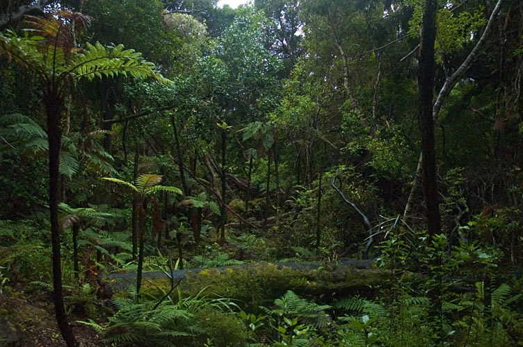
Ulva Island
Gemäßigter Regenwald auf Ulva Island
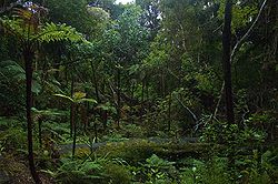
Gewässer Südpazifik
Geographische Lage 46° 56′ 0″ S, 168° 8′ 0″ O-46.933333333333168.13333333333Koordinaten: 46° 56′ 0″ S, 168° 8′ 0″ O
Ulva Island (Neuseeland)
Ulva Island
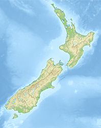
Länge 3,5 km
Fläche 2,7 km²
Einwohner (unbewohnt)

Ulva Island (früher Coopers Island) ist eine kleine Insel im Paterson Inlet vor der Küste von Stewart Island in Neuseeland. Sie ist nach der Insel Ulva der Inneren Hebriden in Schottland benannt.

Ulva Island ist ökologisch wichtig. 1996 wurde die Insel nach einem Ausrottungsprogramm für rattenfrei erklärt und auf der Insel ausgestorbene Vogelarten wurden wieder angesiedelt. Dazu gehören Tieke (Philesturnus carunculatus), Gelbköpfchen (auch Mohua, Mohoua ochrocephala) und Langbeinschnäpper (auch toutouwai, Petroica australis).


Wikimedia Foundation.

Игры ⚽ Поможем сделать НИР

Schlagen Sie auch in anderen Wörterbüchern nach:

  • Ulva Island, New Zealand — Ulva Island is a small island about 3.5 km long lying within Paterson Inlet, which is part of Stewart Island/Rakiura in New Zealand. [ [http://www.doc.govt.nz/templates/PlaceProfile.aspx?id=35674 Ulva Island Open Sanctuary: Southern Islands… …   Wikipedia

  • Ulva (disambiguation) — Ulva may refer to:* Ulva , the generic name for sea lettuce, an edible alga * Ulva, an island in the Inner Hebrides, Scotland * New Ulva, on Danna, Scotland, an island in the Inner Hebrides * Ulva Islands off the coast of Knapdale, Scotland *… …   Wikipedia

  • Ulva —    ULVA, an island and quoad sacra parish, in the parish of Kilninian and Kilmore, district of Mull, and county of Argyll, 12 miles (W. S. W.) from Aros; containing, with the islands of Little Colonsay, Gometray, and Staffa, and a portion of the… …   A Topographical dictionary of Scotland

  • Ulva — Infobox Scottish island | GridReference=NM410396 celtic name=Ulbha norse name=Ulv oy/Ulfrsey meaning of name=Old Norse for wolf island or Ulfr s island area=1,990 ha area rank=35 highest elevation=Beinn Chreagach 313 m Population=16 population… …   Wikipedia

  • Ulva lactuca — Taxobox color = lightgreen name = Ulva lactuca domain = Eukaryota regnum = Protista phylum = Chlorophyta classis = Ulvophyceae ordo = Ulvales familia = Ulvaceae genus = Ulva species = U. lactuca binomial = Ulva lactuca binomial authority =… …   Wikipedia

  • Ulva Ferry — infobox UK place country = Scotland official name= Ulva Ferry gaelic name= population= os grid reference= latitude= 56.47 longitude= 6.13 unitary scotland= Argyll and Bute lieutenancy scotland= Argyll and Bute constituency westminster= Argyll and …   Wikipedia

  • Ulva (Mull) — Pour les articles homonymes, voir Ulva. Ulva Géographie Pays …   Wikipédia en Français

  • Ulva — Para Lechuga de mar, véase Ulva lactuca. Fluraichean faisg air Ardalum, ann an Ulbha. La Isla de Ulva (o simplemente Ulva; en gaélico escocés Ulbha) es un isla del archipiélago de las Hébridas Interiores, en la costa occidental de Escocia …   Wikipedia Español

  • Ulva — noun A small island in the Inner Hebrides …   Wiktionary

  • Stewart Island/Rakiura — Stewart Island/RakiuraTerritorial AuthorityNameStewart Island/RakiuraPopulation402 (2006)Land area1,746 km²Regional CouncilNameSouthland Stewart Island / Rakiura is the third largest island of New Zealand. It lies convert|30|km south of South… …   Wikipedia

Share the article and excerpts

Direct link
Do a right-click on the link above
and select “Copy Link”