Uncompahgre National Forest
- Uncompahgre National Forest
-

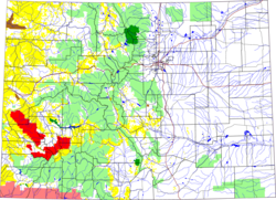
Colorado mit dem Uncompahgre National Forest der mit Rot gekennzeichnet ist.
Der Uncompahgre National Forest in ein 4000 km² großer National Forest im Südwesten des US-Bundesstaates Colorado in den Countys Gunnison, Hinsdale, Mesa, Montrose, Ouray und San Miguel. Er grenzt im Süden an den San Juan National Forest. Der Wald teilt sich in zwei Teile, das Uncompahgre Plateau und die San Juan Mountains. Im Umcompahgre National Forest liegen auch die drei Wildgebiete Umcompahgre Wilderness, Mount Sneffels Wilderness und Lizard Head Wilderness.
Weblinks
Kategorien: - Waldgebiet in Nordamerika
- National Forest (Vereinigte Staaten)
- Geographie (Colorado)
Wikimedia Foundation.
Schlagen Sie auch in anderen Wörterbüchern nach:
Uncompahgre National Forest — is a U.S. National Forest covering 955,229 acres (1,492.55 sq mi, or 3,865.68 km²) [ [http://www.fs.fed.us/land/staff/lar/2007/TABLE 6.htm Table 6 NFS Acreage by State, Congressional District and County] United States Forest Service September 30 … Wikipedia
National Forest — Tongass Nationalforst in Alaska Ein Nationalforst (engl. National Forest) ist in den Vereinigten Staaten von Amerika ein Waldgebiet unter der Kontrolle der Bundesregierung, das vom US Forest Service verwaltet wird. Größter Nationalforst ist mit… … Deutsch Wikipedia
Gunnison National Forest — Der Gunnison National Forest ist ein 6900 km² großer National Forest im Westen des US Bundesstaates Colorado in den Countys Mesa, Gunnison, Hinsdale und Saguache. Er grenzt im Norden an den White River National Forest, im Westen an den Grand Mesa … Deutsch Wikipedia
Montezuma National Forest — was established as the Montezuma Forest Reserve by the U.S. Forest Service in Colorado on June 13, 1905 with 576,719 acres (2,333.90 km2). It became a National Forest on March 4, 1907. On July 1, 1908 part of Ouray National Forest was added … Wikipedia
Fruita National Forest — was as the Fruita Forest Reserve established by the U.S. Forest Service in Colorado on February 24, 1906 with 7,680 acres. It became a National Forest on March 4, 1907. On July 1, 1908 Fruita was transferred to Uncompahgre National Forest and the … Wikipedia
Ouray National Forest — was established by the U.S. Forest Service in Colorado on February 22, 1907 with 273,175 acres (1,105.50 km2). On July 1, 1908 the entire forest was divided between Montezuma National Forest and Uncompahgre National Forest and the name was… … Wikipedia
Grand Mesa National Forest — The Grand Mesa National Forest is a U.S. National Forest in Mesa, Delta and Garfield Counties in Western Colorado. It borders the White River National Forest to the north and the Gunnison National Forest to the east. The forest covers most of… … Wikipedia
San Juan National Forest — The San Juan National Forest is a U.S. National Forest covering over 1,878,846 acres (2,935.7 sq mi, or 7,603.42 km²) in Archuleta, Conjeos, Dolores, Hinsdale, La Plata, Mineral, Montezuma, Rio Grande, San Miguel and San Juan Counties in western… … Wikipedia
Gunnison National Forest — Copper Lake Trail, near Crested Butte in the Gunnison National Forest The Gunnison National Forest is a U.S. National Forest covering 1,672,136 acres (2,612.71 sq mi, or 6,766.89 km²) [1] in Mesa, Gunnison, Hinsdale and … Wikipedia
Uncompahgre River — Der vom Uncompahgre Fluss gebildete Uncompahgre Gorge im HerbstVorlage:Infobox Fluss/KARTE fehlt … Deutsch Wikipedia

