Uralla Shire

Uralla Shire
Shire of Uralla
Australia-Map-NSW-LGA-Uralla.png
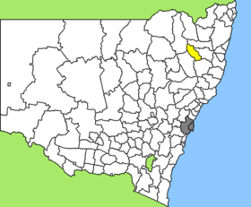
Lage des Uralla Shire in New South Wales
Gliederung
Staat: Australien Australien
Bundesstaat: Flag of New South Wales.svg New South Wales
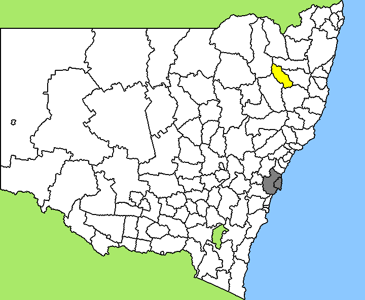
Verwaltungssitz: Uralla
Daten und Zahlen
Fläche: 3.230 km²
Einwohner: 5.734 (2006) [1]
Bevölkerungsdichte: 1,8 Einwohner je km²
Wards: 3
-30.566666666667151.4

Uralla Shire ist ein lokales Verwaltungsgebiet (LGA) im australischen Bundesstaat New South Wales. Das Gebiet ist 3.230 km² groß und hat etwa 5.700 Einwohner.

Uralla liegt im Nordosten des Staates etwa 510 km nördlich der Metropole Sydney und 490 km südlich von Brisbane. Das Gebiet umfasst 53 Ortsteile und Ortschaften, darunter Arding, Brushgrove, Kentucky, Kentucky South, Kingstown, Rocky River, Torryburn, Uralla, Wollun und Yarrowyck sowie Teile von Bundarra und Dumaresq. Der Sitz des Shire Councils befindet sich in der Stadt Uralla in der Südosthälfte der LGA, wo etwa 2.300 Einwohner leben.

Verwaltung

Der Uralla Shire Council hat neun Mitglieder, die von den Bewohnern der drei Wards gewählt werden (je drei aus den Wards A, B und C). Diese drei Bezirke sind unabhängig von den Ortschaften festgelegt. Aus dem Kreis der Councillor rekrutiert sich auch der Mayor (Bürgermeister) des Councils.

Weblinks

Einzelnachweise

  1. Australian Bureau of Statistics (25. Oktober 2007): Uralla (A) (Local Government Area) (Englisch). 2006 Census QuickStats. Abgerufen am 6. April 2010.

Wikimedia Foundation.

Игры ⚽ Поможем написать реферат

Schlagen Sie auch in anderen Wörterbüchern nach:

  • Uralla Shire Council — Infobox Australian Place | type = lga name = Uralla Shire caption = Location in New South Wales state = New South Wales region = New England area = 3230 est = seat = Uralla (Salisbury Street)cite web title=Glen Innes Severn Shire Council… …   Wikipedia

  • Uralla, New South Wales — Infobox Australian Place | type = town name = Uralla state = nsw caption = Uralla, NSW lga = Uralla Shire Council county = Sandon postcode = 2358 est = 1855 pop = 2,304 elevation= 1012 maxtemp = 19.7 mintemp = 6.3 rainfall = 802.9 stategov =… …   Wikipedia

  • Uralla — /juˈrælə/ (say yooh raluh) noun a town and shire in the New England district of NSW, south west of Armidale …  

  • Wakool Shire — Shire of Wakool New South Wales Location in New South Wales Population: 4,427(2009) …   Wikipedia

  • Muswellbrook Shire — New South Wales Location in New South Wales Population …   Wikipedia

  • Conargo Shire — New South Wales Location in New South Wales Population: 1,700(2009) …   Wikipedia

  • Murray Shire — This article is about the Murray Shire in New South Wales. For the Western Australia shire, see Shire of Murray. Murray Shire New South Wales …   Wikipedia

  • Narrandera Shire — New South Wales Location in New South Wales Population: 6 …   Wikipedia

  • Cobar Shire — New South Wales Location in New South Wales Population: 5 …   Wikipedia

  • Cowra Shire — New South Wales Location in NSW Population: 12,945(2009) …   Wikipedia

Share the article and excerpts

Direct link
Do a right-click on the link above
and select “Copy Link”