Uruppu

Uruppu
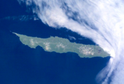
NASA-Bild der Insel Urup

Urup (russisch: Уруп), auf japanisch Uruppu (得撫島, -tō) genannt, ist eine Insel des Kurilen-Archipels. Die Insel gehört zu Russland.

Geographie

Urup liegt nordöstlich von Hokkaidō, etwa auf der geographischen Breite der Südspitze Sachalins. Die Insel hat eine Fläche von 1.430 km².

Ihre höchste Erhebung ist mit 1.426 Metern der Berg Wyssokaja. Eine Reihe von Bergketten, die am Fuß ineinander verschmolzen sind, ist vulkanischen Ursprungs; von den etwa 25 Vulkanen sind zwei noch aktiv: der Tresubez und die Berga.

Geschichte und Politik

Urup wurde ursprünglich von Ainu bewohnt. Im 18. Jahrhundert kamen russische Händler und Jäger auf die Insel, was 1772 zu Konflikten mit den Ainu führte. 1801 erklärte die japanische Regierung Urup zu japanischem Territorium und gliederte die Insel in die Provinz Ezo ein, die heutige Präfektur Hokkaidō.

1855 wurde die Insel durch den Vertrag von Shimoda zu russischem Territorium. 1875 wurde Urup durch den Vertrag von Sankt Petersburg wieder zu japanischem Gebiet. 1945 wurde Urup, wie alle anderen Inseln der Kurilen auch, von sowjetischen Truppen besetzt und gehört seit 1946 zum sowjetischen bzw. seit 1991 zum russischen Staatsgebiet. Japan gab 1951 im Friedensvertrag von San Francisco alle Ansprüche auf die Insel auf.

45.933333333333150.033333333337Koordinaten: 45° 56′ N, 150° 2′ O


Wikimedia Foundation.

Игры ⚽ Поможем написать курсовую

Schlagen Sie auch in anderen Wörterbüchern nach:

  • Organization of Kita and Minami Fortresses — The Kita and Minami Fortresses (Japanese kita, north and minami, south ) were defensive structures of the Imperial Japanese Army and Imperial Japanese Navy in the Kuril Archipelago. The most northerly points were on the Kokutan and Kurabu Zaki… …   Wikipedia

  • Pavel Lebedev-Lastochkin — Pavel Sergeyevich Lebedev Lastochkin (Russian: Павел Сергеевич Лебедев Ласточкин) was a Russian merchant from Yakutsk who, in the late 18th century, became one of the first Russians to make contact with the Japanese. The government had hoped to… …   Wikipedia

  • Kuril Islands — Location of Kuril Islands in the Western Pacific. Matua Isl …   Wikipedia

  • Evacuation of Karafuto and Kuriles — The evacuation of Karafuto and the Kuriles refers to the events that took place as the Japanese population left these areas, to the north west of the main islands of Japan, inAugust 1945. (Simultaneously Chosen, Kwantung and Manchukuo were being… …   Wikipedia

  • Nemuro-shicho — Lage der Unterpräfektur Nemuro Nemuro (jap. 根室支庁, Nemuro shichō) ist eine Unterpräfektur der Präfektur Hokkaidō. Sie hat, einschließlich der von Japan beanspruchten Südkurilen (Kurilenkonflikt) eine Fläche von 8.533,96 km² und eine Einwohnerzahl… …   Deutsch Wikipedia

  • Nemuro-shichō — Lage der Unterpräfektur Nemuro Nemuro (jap. 根室支庁, Nemuro shichō) ist eine Unterpräfektur der Präfektur Hokkaidō. Sie hat, einschließlich der von Japan beanspruchten Südkurilen (Kurilenkonflikt) eine Fläche von 8.533,96 km² und eine Einwohnerzahl… …   Deutsch Wikipedia

  • Kuril Islands dispute — Coordinates: 44°6′N 146°42′E / 44.1°N 146.7°E / 44.1; 146.7 …   Wikipedia

  • Imperial Japanese Army Railways and Shipping Section — The Imperial Japanese Army Railway and Shipping Section was the logistics unit of the Imperial Japanese Army charged with shipping personnel, materiel and equipment from metropolitan Japan to the combat front overseas. TOC RailwayUnder it were… …   Wikipedia

  • Kurilen — Lage der Kurilen zwischen Hokkaidō und Kamtschatka Gewässer Pazifischer Ozean …   Deutsch Wikipedia

  • Südkurilen — Lage der Kurilen zwischen Hokkaidō und Kamtschatka Die Kurilen, Sachalin (links), Hokkaidō (links unten) und Kamtschatka (rechts oben) (NASA Satellitenfoto) Di …   Deutsch Wikipedia

Share the article and excerpts

Direct link
Do a right-click on the link above
and select “Copy Link”