Battery Park City

Battery Park City
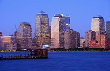
World Financial Center in Battery Park City
Lage der Battery Park City in Lower Manhattan

Battery Park City ist ein Stadtteil im Südwesten von Manhattan in New York, der auf zwischen 1967 und 1976 aufgeschüttetem Land am Ufer des Hudson River entstand.

Wie auch der namengebende Battery Park gehört der Stadtteil administrativ zum Manhattan Community Board 1. Die Einwohnerzahl betrug beim Zensus im Jahr 2000 7951 Einwohner; dies waren 2377 mehr als bei der Zählung von 1990.[1]

Battery Park City grenzt im Osten an die West Street mit den Stadtteilen Financial District und TriBeCa. Es umfasst die Gebäude des World Financial Center, das Museum of Jewish Heritage, die Warenterminbörse New York Mercantile Exchange sowie die Stuyvesant High School.

Inhaltsverzeichnis

Siehe auch

Literatur

  • David Gordon: Battery Park City. Politics and Planning on the New York Waterfront. Routledge 1997, ISBN 90-5699-558-8

Einzelnachweise

  1. Statistiken des Manhattan Community Board 1

Weblinks

 Commons: Battery Park City – Sammlung von Bildern, Videos und Audiodateien
40.712687-74.015665

Wikimedia Foundation.

Игры ⚽ Нужно решить контрольную?

Schlagen Sie auch in anderen Wörterbüchern nach:

  • Battery Park City — is a 92 acre (0.4 km²) planned community at the southwestern tip of lower Manhattan in New York City, United States. The land upon which it stands was created from the Hudson River using 1.2 million cubic yards (917,000 m³) of dirt and rocks… …   Wikipedia

  • Battery Park City — Saltar a navegación, búsqueda El Rockfeller Park en Battery Park City. Battery Park City es una comunidad planificada de un área de 0.4 km2 en el extremo sudoeste de Manhattan en Nueva York. La zona sobre la que se levanta ha sido ganada del Río… …   Wikipedia Español

  • Battery Park City — es una comunidad planificada de un área de 0.4 km² en el extremo sudoeste de Manhattan en Nueva York. La zona sobre la que se levanta ha sido ganada del Río Hudson usando 917,000 metros cúbicos de tierra y rocas excavadas durante la construcción… …   Enciclopedia Universal

  • Battery Park City — 40° 42′ 46″ N 74° 00′ 56″ W / 40.71268, 74.01566 …   Wikipédia en Français

  • Battery Park City Authority — The Hugh L. Carey Battery Park City Authority is a New York State public benefit corporation whose mission is to plan, create, co ordinate and maintain a balanced community of commercial, residential, retail, and park space within its designated… …   Wikipedia

  • Battery Park — is a 25 acre (10 hectare) public park located at the Battery, the southern tip of the New York City borough of Manhattan, facing New York Harbor. The Battery is named for the artillery battery that was stationed there at various times by the… …   Wikipedia

  • Battery Park — Saltar a navegación, búsqueda Ubicacion Battery Park encerrada en un circulo. Battery Park es un parque de 25 acres (10 hectáreas), situado en la punta sur de la ciudad de Nueva York en Lower Manhattan, frente al puerto. El nombre …   Wikipedia Español

  • Battery Park — 40° 42′ 13″ N 74° 00′ 58″ W / 40.70371, 74.01609 …   Wikipédia en Français

  • Battery Park (disambiguation) — Battery Park is the name of:* Battery Park (New York), located at The Battery at the southern tip of Manhattan, where artillery had also been stationed in past centuries. * Battery Park (Delaware), also called The Battery , a small park down by… …   Wikipedia

  • Battery Park (Burlington, VT) — Battery Park is a public park overlooking Lake Champlain at the western end of downtown Burlington, Vermont. The park includes a bandshell, a playground, and various monuments, including a bronze statue of Civil War General William W. Wells, and… …   Wikipedia

Share the article and excerpts

Direct link
Do a right-click on the link above
and select “Copy Link”