Warraber

Warraber

w1

Sue Island
Lage der Torres-Strait-Inseln
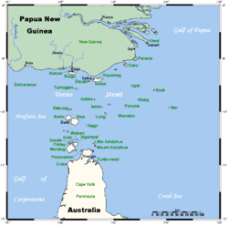
Gewässer Pazifischer Ozean
Inselgruppe The Three Sisters (Torres Strait)
Geographische Lage 10° 12′ 25″ S, 142° 49′ 30″ O-10.207142.8251Koordinaten: 10° 12′ 25″ S, 142° 49′ 30″ O
Länge 1,3 km
Breite 700 m
Fläche 0,8 km²dep1
Höchste Erhebung 1 m
Einwohner 216 (Stand: 2001) dep1

Sue Island, auch als Warraber oder Warraber Island bekannt, ist eine Insel in der Mitte der Torres Strait, einer Wasserstraße zwischen Australien und Papua-Neuguinea. Von Thursday Island, der Hauptinsel in der Torres Strait, ist Sue Island etwa 80 km entfernt.

Sue Island liegt zwischen den unbewohnten Inselchen Bet Island und Poll Island, und bildet mit diesen die "Three Sisters" genannte Inselgruppe. Geographisch zählen diese zum Archipel der Torres-Strait-Inseln, verwaltungstechnisch zu den Central Islands, einer Inselregion im Verwaltungsbezirk Torres Shire von Queensland.

Sue ist eine kleine Koralleninsel, die kaum einen Meter über die Wasseroberfläche ragt. Auf der knapp 0,8 km² großen Landfläche leben dennoch 216 Menschen (Stand: 2001). Ferner verfügt die Insel über eine ca. 1.000 Meter lange Start- und Landebahn für Kleinflugzeuge.

Siehe auch


Wikimedia Foundation.

Игры ⚽ Нужно решить контрольную?

Schlagen Sie auch in anderen Wörterbüchern nach:

  • Warraber Island Airport — airport codes|SYU|YWBS is an airport in Sue Islet, Queensland, Australia.Airlines and destinations*Aero Tropics Air Services (Bamaga, Coconut Island, Horn Island, Saibai Island, Yam Island) *Regional Pacific Airlines (Horn Island, Yam… …   Wikipedia

  • Warraber Island — w1 Sue Island Lage der Torres Strait Inseln Gewässer Pazifischer Ozean Inselgruppe …   Deutsch Wikipedia

  • Sue Islet (Queensland) — Warraber (Sue) Island is the middle island of The Three Sisters, Torres Strait 100km North East of Thursday Island Queensland, Australia in the Vigilant Channel Torres Strait. Situated on a beautiful coral cay, Sue Island boasts an abundance of… …   Wikipedia

  • Cay — A cay (also spelled key or quay; pronounced as key IPA: /kiː/) is a small, low elevation, sandy island formed on the surface of coral reefs. Cays occur in tropical environments throughout the Pacific, Atlantic and Indian Oceans (including in the… …   Wikipedia

  • Coconut Island Airport — (IATA: CNC[1], ICAO: YCCT[2]) is an airport located on Coconut Island (Poruma Island) in Queensland, Australia. Airlines and destinations Aero Tropics Air Services (Horn Island, Warraber Island, Yam Island, Yorke Island) Regional Pacific… …   Wikipedia

  • Torres Strait Islands Regional Council — Infobox Australian Place | type = lga name = Torres Strait Islands Region state = qld caption = pop = 4,298 (2006 census) area = 491.1 est = 2008 seat = Thursday Island mayor = Cr Fred Gela region = Far North Queensland logosize = url = stategov …   Wikipedia

  • Torres Strait Islands — The Torres Strait Islands are a group of at least 274 small islands which lie in Torres Strait, the waterway separating far northern continental Australia s Cape York Peninsula and the island of New Guinea. They are part of Queensland, a… …   Wikipedia

  • Horn Island Airport — Infobox Airport name = Horn Island Airprot IATA = HID ICAO = YHID location = Horn Island, Queensland elevation f = 43 elevation m = r1 number = 08/26 r1 length f = r1 length m = 1389 r1 surface = Asphalt r2 number = 14/32 r2 length m = 1235 r2… …   Wikipedia

  • Sue Island — w1 Sue Island Landsat Bild von Sue Island Gewässer Pazifischer Ozean …   Deutsch Wikipedia

  • The Three Sisters (Torres Strait) — The Three Sisters Landsat Bild der Gruppe Von Nord nach Süd: Bet Island, Sue Island und Poll Island …   Deutsch Wikipedia

Share the article and excerpts

Direct link
Do a right-click on the link above
and select “Copy Link”