Warraber Island

Warraber Island

w1

Sue Island
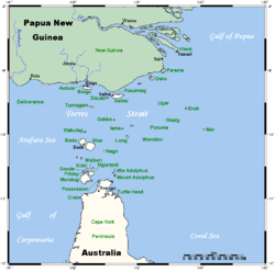
Lage der Torres-Strait-Inseln
Gewässer Pazifischer Ozean
Inselgruppe The Three Sisters (Torres Strait)
Geographische Lage 10° 12′ 25″ S, 142° 49′ 30″ O-10.207142.8251Koordinaten: 10° 12′ 25″ S, 142° 49′ 30″ O
Länge 1,3 km
Breite 700 m
Fläche 0,8 km²dep1
Höchste Erhebung 1 m
Einwohner 216 (Stand: 2001) dep1

Sue Island, auch als Warraber oder Warraber Island bekannt, ist eine Insel in der Mitte der Torres Strait, einer Wasserstraße zwischen Australien und Papua-Neuguinea. Von Thursday Island, der Hauptinsel in der Torres Strait, ist Sue Island etwa 80 km entfernt.

Sue Island liegt zwischen den unbewohnten Inselchen Bet Island und Poll Island, und bildet mit diesen die "Three Sisters" genannte Inselgruppe. Geographisch zählen diese zum Archipel der Torres-Strait-Inseln, verwaltungstechnisch zu den Central Islands, einer Inselregion im Verwaltungsbezirk Torres Shire von Queensland.

Sue ist eine kleine Koralleninsel, die kaum einen Meter über die Wasseroberfläche ragt. Auf der knapp 0,8 km² großen Landfläche leben dennoch 216 Menschen (Stand: 2001). Ferner verfügt die Insel über eine ca. 1.000 Meter lange Start- und Landebahn für Kleinflugzeuge.

Siehe auch


Wikimedia Foundation.

Игры ⚽ Поможем написать реферат

Schlagen Sie auch in anderen Wörterbüchern nach:

  • Warraber Island Airport — airport codes|SYU|YWBS is an airport in Sue Islet, Queensland, Australia.Airlines and destinations*Aero Tropics Air Services (Bamaga, Coconut Island, Horn Island, Saibai Island, Yam Island) *Regional Pacific Airlines (Horn Island, Yam… …   Wikipedia

  • Warraber — w1 Sue Island Lage der Torres Strait Inseln Gewässer Pazifischer Ozean Inselgruppe …   Deutsch Wikipedia

  • Coconut Island Airport — (IATA: CNC[1], ICAO: YCCT[2]) is an airport located on Coconut Island (Poruma Island) in Queensland, Australia. Airlines and destinations Aero Tropics Air Services (Horn Island, Warraber Island, Yam Island, Yorke Island) Regional Pacific… …   Wikipedia

  • Horn Island Airport — Infobox Airport name = Horn Island Airprot IATA = HID ICAO = YHID location = Horn Island, Queensland elevation f = 43 elevation m = r1 number = 08/26 r1 length f = r1 length m = 1389 r1 surface = Asphalt r2 number = 14/32 r2 length m = 1235 r2… …   Wikipedia

  • Sue Island — w1 Sue Island Landsat Bild von Sue Island Gewässer Pazifischer Ozean …   Deutsch Wikipedia

  • Darnley Island Airport — (IATA: NLF) is an airport in Darnley Island, Queensland, Australia. Airlines and destinations Aero Tropics Air Services (Horn Island, Murray Island, Yorke Island) Regional Pacific Airlines (Yorke Island) Coordinates …   Wikipedia

  • Mornington Island Airport — (IATA: ONG, ICAO: YMTI) is an airport on Mornington Island, Queensland, Australia. in 2006 the airport received $200,853 in funds to improve security.[1] Airlines and destinations Airlines Destinations Skytrans Airlines Burketown, Doomadgee …   Wikipedia

  • Murray Island Airport — IATA: MYI – ICAO: YMUI Summary Airport type Public Location Murray Island, Queensland, Australia …   Wikipedia

  • Saibai Island Airport — airport codes|SBR|YSII is an airport in Saibai Island, Queensland, Australia.Airlines and Destinations*Aero Tropics Air Services (Boigu Island, Horn Island, Warraber Island, Yam Island) *Regional Pacific Airlines (Badu Island, Horn… …   Wikipedia

  • Yam Island Airport — airport codes|XMY|YYMI is an airport in Yam Island, Queensland, Australia.Airlines and destinations*Aero Tropics Air Services (Bamaga, Coconut Island, Horn Island, Warraber Island, Yorke Island) *Regional Pacific Airlines (Coconut… …   Wikipedia

Share the article and excerpts

Direct link
Do a right-click on the link above
and select “Copy Link”