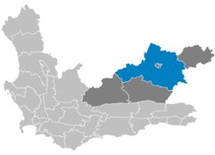
Beaufort West Local Municipality
- Beaufort West Local Municipality
-
[[Image:|thumb|300px|Gemeinde ]] Beaufort West ist eine Gemeinde im Distrikt Zentralkaroo, Provinz Westkap in Südafrika. Im Jahr 2001 lebten 37.107 Einwohner auf einer Gesamtfläche von 16.330 km². Der Sitz der Gemeindeverwaltung ist Beaufort West. [1]
Die Gemeinde wurde 1818 gegründet und nach Henry Somerset, 5. Herzog von Beaufort Beaufort benannt. Somerset war der Vater des Gouverneurs Lord Charles Somersets, des Gouverneurs der Kapkolonie. [2]
Städte/Orte
- Beaufort West
- Die Laning
- Essopville
- Hillside
- Hospital Hill
- Merweville
- Nelspoortrt
- New Town
- Newlands
- Nieuveld Park
- Prince Valley
- Rustdene
- Sidesavrwa
Sehenswürdigkeiten
Weblinks
- ↑ Gemeindegrenzen Südafrika
- ↑ Namensbedeutung Gemeinden
-32.3522.5833333333337Koordinaten: 32° S, 23° O
Wikimedia Foundation.
Schlagen Sie auch in anderen Wörterbüchern nach:
Beaufort West Local Municipality — Zamuni code= location=Central Karoo District Municipality, Western Cape area=16,334 seat=Beaufort West neighbours= mayor= vacant population=37,107 population density=2.27 habitations= habitation density= races=73.2% Coloured, 15.8% Black, 10.9%… … Wikipedia
Beaufort West — Neo Gothic Dutch Reformed Mother Church, built in 1892 … Wikipedia
Beaufort West (Gemeinde) — Beaufort West Beaufort West Local Municipality Symbole … Deutsch Wikipedia
Mossel Bay Local Municipality — Mossel Bay Municipality Municipality Location of Mossel Bay Local Municipality … Wikipedia
Matzikama Local Municipality — Matzikama Plaaslike Munisipaliteit UMasipala weNgingqi yaseMatzikama Local municipality … Wikipedia
Drakenstein Local Municipality — Drakenstein Plaaslike Munisipaliteit UMasipala weNgingqi yaseDrakenstein Local municipality … Wikipedia
Oudtshoorn Local Municipality — Local municipality … Wikipedia
Overstrand Local Municipality — Overstrand Plaaslike Munisipaliteit UMasipala weNgingqi yaseOverstrand Local municipality … Wikipedia
Laingsburg Local Municipality — Zamuni code= WC051 location= Central Karoo District Municipality, Western Cape Province area= 8,781 neighbours= mayor= Willem Theron (DA) population= 6,681 population density= 0.76 habitations= habitation density= races= languages= website=… … Wikipedia
Central Karoo District Municipality — Zamuni code=DC5 location=Western Cape area=38853 seat=Beaufort West neighbours=Karoo (north), Cacadu (east), Eden (south), Cape Winelands (west), Namakwa (northwest) mayor=Doreen Hugo (ANC) population=57321 population density=1.4753… … Wikipedia

