Wat’s Dyke

Wat’s Dyke
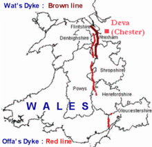
Lage von Wat’s Dyke (braune Linie) und Offa’s Dyke (rote Linie)
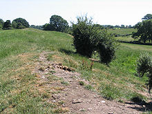
Wat’s Dyke nahe Northop

Wat’s Dyke ist ein über 60 km langer Wall in der walisisch-englischen Grenzregion Welsh Marches. Der Wall verläuft hier unter anderem an Oswestry vorbei.

Die Historiker einigten sich auf das achte Jahrhundert als Entstehungszeitraum, doch verweisen C14-Messungen nun auf das fünfte Jahrhundert.

Literatur

  • Margaret Worthington: Wat’s Dyke: An Archaeological and Historical Enigma. Bulletin John Rylands Library, Manchester, Vol 79, no. 3, 1997.
  • H. R. Hannaford: Archaeological on Wat’s Dyke at Maes-y-Clawdd. Archaeology Service, Shropshire County Council, report no. 132., December 1997.
52.986666666667-3.0286111111111

Wikimedia Foundation.

Игры ⚽ Поможем написать реферат

Schlagen Sie auch in anderen Wörterbüchern nach:

  • Wat's Dyke — is a 40 mile earthwork running through the northern Welsh Marches from Basingwerk Abbey on the River Dee estuary, passing to the east of Oswestry and onto Maesbury in Shropshire. It runs generally parallel to Offa s Dyke, sometimes within a few… …   Wikipedia

  • Wat's Dyke — Der Wat’s Dyke ist ein über 60 km langer Wall in Wales. Die Grenzregion zwischen England und Wales heißt Welsh Marches. Der Wall verläuft hier unter anderem an Oswestry vorbei. Die Historiker einigten sich auf das achte Jahrhundert als… …   Deutsch Wikipedia

  • Dyke (Begriffsklärung) — Dyke steht für: Dyke, Gesteinsart Dyke, eine Rolle lesbischer Frauen, siehe Butch und Femme Bokerley Dyke, römisch britische Landwehr Car Dyke, Kanal in England Foss Dyke, Kanal in England Great Dyke, Gesteinsgürtel in Simbabwe Offa’s Dyke,… …   Deutsch Wikipedia

  • Wat's Dyk — Der Wat’s Dyke ist ein über 60 km langer Wall in Wales. Die Grenzregion zwischen England und Wales heißt Welsh Marches. Der Wall verläuft hier unter anderem an Oswestry vorbei. Die Historiker einigten sich auf das achte Jahrhundert als… …   Deutsch Wikipedia

  • Offa's Dyke — Coordinates: 52°20′38″N 3°02′56″W / 52.344°N 3.049°W / 52.344; 3.049 …   Wikipedia

  • Offa’s Dyke — Lage von Offa’s Dyke (rote Linie) und Wat’s Dyke (braune Linie) …   Deutsch Wikipedia

  • Offa's Dyke — Earthwork in western England. It stretches 169 mi (270 km) from the River Severn near Chepstow to the seaward end of the River Dee s estuary. It was built by Offa of Mercia to fortify the boundary between his kingdom and the lands of the Welsh;… …   Universalium

  • Offa of Mercia — This article is about Offa of Mercia. For other meanings of Offa, see Offa (disambiguation). Offa Depiction of Offa in a thirteenth century manuscript King of Mercia Reign 757 – July 796 Predecessor …   Wikipedia

  • Offa de Mercie — Traduction à relire Offa of Mercia → …   Wikipédia en Français

  • Offa de mercie — Traduction à relire Offa of Mercia → …   Wikipédia en Français

Share the article and excerpts

Direct link
Do a right-click on the link above
and select “Copy Link”