Wingecarribee Shire

Wingecarribee Shire
Shire of Wingecarribee
Australia-Map-NSW-LGA-Wingecarribee.png
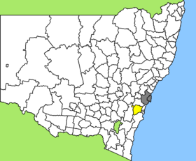
Lage des Wingecarribee Shire in New South Wales
Gliederung
Staat: Australien Australien
Bundesstaat: Flag of New South Wales.svg New South Wales
Verwaltungssitz: Moss Vale
Daten und Zahlen
Fläche: 2.689 km²
Einwohner: 42.272 (2006) [1]
Bevölkerungsdichte: 16 Einwohner je km²
-34.55150.36666666667

Wingecarribee Shire ist ein lokales Verwaltungsgebiet (LGA) im australischen Bundesstaat New South Wales. Das Gebiet ist 2.689 km² groß und hat etwa 44.000 Einwohner.

Wingecarribee liegt in der Region Illawarra des Staates etwa 120 km südwestlich der Metropole Sydney und 160 km nordöstlich der australischen Hauptstadt Canberra. Das Gebiet umfasst 70 Ortsteile und Ortschaften, darunter Balmoral Village, Berrima, Bowral, Bundanoon, Burradoo, Burrawang, Colo Vale, Exeter, Fitzroy Falls, Hill Top, Mittagong, Penrose, Robertson, Sutton Forest, Willow Vale, Wingello, Yerrinbool sowie ein Teil von Buxton. Der Sitz des Shire Councils befindet sich in der Ortschaft Moss Vale im Zentrum der LGA, wo etwa 6.700 Einwohner leben.

Inhaltsverzeichnis

Verwaltung

Der Wingecarribee Shire Council hat 12 Mitglieder, die von den Bewohnern der LGA gewählt werden. Wingecarribee ist nicht in Bezirke untergliedert. Aus dem Kreis der Ratsmitglieder, der Councillors, rekrutiert sich der Bürgermeister (Mayor) des Shire.

Sonstiges

Die Bewohner von Bundanoon haben als wahrscheinlich erste Gemeinde weltweit den Verkauf von Wasser in Trinkflaschen verboten.[2]

Weblinks

Einzelnachweise

  1. Australian Bureau of Statistics (25. Oktober 2007): Wingecarribee (A) (Local Government Area) (Englisch). 2006 Census QuickStats. Abgerufen am 6. April 2010.
  2. Kleinstadt verbietet Flaschenwasser tageszeitung vom 29.September 2009

Wikimedia Foundation.

Игры ⚽ Нужен реферат?

Schlagen Sie auch in anderen Wörterbüchern nach:

  • Wingecarribee Shire Council — Infobox Australian Place | type = lga name = Wingecarribee Shire state = nsw caption = Location in NSW pop = 40,636Census 2001 AUS|id=LGA18350|name=Wingecarribee (A) (Local Government Area)|accessdate=2007 06 30|quick=on] area = 2689 est = seat …   Wikipedia

  • Willow Vale, New South Wales (Wingecarribee) — Willow Vale is a Northern Village of the Southern Highlands of New South Wales, Australia, in Wingecarribee Shire. It is located 1km north of Mittagong and is often considered part of Braemar along with its neighbour Balaclava. (Pop. 1189 Census… …   Wikipedia

  • Penrose, New South Wales (Wingecarribee) — Penrose is a small town in the Southern Highlands of New South Wales, Australia, in Wingecarribee Shire. It is has a station on the Main Southern railway line served by CityRail s Southern Highlands services. Penrose also has a small general… …   Wikipedia

  • Wakool Shire — Shire of Wakool New South Wales Location in New South Wales Population: 4,427(2009) …   Wikipedia

  • Muswellbrook Shire — New South Wales Location in New South Wales Population …   Wikipedia

  • Conargo Shire — New South Wales Location in New South Wales Population: 1,700(2009) …   Wikipedia

  • Murray Shire — This article is about the Murray Shire in New South Wales. For the Western Australia shire, see Shire of Murray. Murray Shire New South Wales …   Wikipedia

  • Narrandera Shire — New South Wales Location in New South Wales Population: 6 …   Wikipedia

  • Cowra Shire — New South Wales Location in NSW Population: 12,945(2009) …   Wikipedia

  • Nambucca Shire — New South Wales Location in New South Wales Population: 19,186(200 …   Wikipedia

Share the article and excerpts

Direct link
Do a right-click on the link above
and select “Copy Link”