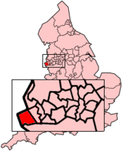
- Wirral (Borough)
-
Metropolitan Borough of Wirral 
Status Metropolitan Borough Region North West England Zerem. Grafschaft Merseyside Trad. Grafschaft Cheshire Verwaltungssitz Wallasey Fläche 157,05 km² (208.) Einwohner 310.200 (13.) ONS-Code 00CB Website www.wirral.gov.uk Wirral ist ein Verwaltungsbezirk mit dem Status eines Metropolitan Borough in der Grafschaft Merseyside in England, der nach der Halbinsel The Wirral benannt ist. Der Bezirk umfasst die nördliche Hälfte dieser Halbinsel und liegt am Mersey gegenüber von Liverpool, an der Nordseite wird er durch die Irische See begrenzt. Verwaltungssitz ist die Stadt Wallasey. Zum Bezirk gehören außerdem die Orte Bebington, Bidston, Birkenhead, Heswall, Hoylake, New Brighton und West Kirby.
Die Reorganisation der Grenzen und der Kompetenzen der lokalen Behörden führte 1974 zur Bildung des Metropolitan Borough. Fusioniert wurden dabei die County Boroughs von Birkenhead und Wallesey, der Municipal Borough von Bebington und die Urban Districts von Hoylake und Wirral. Diese Gebietskörperschaften gehörten zuvor zur Grafschaft Cheshire.
1986 wurde Wirral faktisch eine Unitary Authority, als die Zentralregierung die übergeordnete Verwaltung der Grafschaft auflöste. Wirral blieb für zeremonielle Zwecke Teil von Merseyside, wie auch für einzelne übergeordnete Aufgaben wie Polizei, Feuerwehr und öffentlicher Verkehr.
Schlagen Sie auch in anderen Wörterbüchern nach:
Wirral Transport Museum — is a museum situated 1 mile from the Mersey Ferry service at Woodside, Birkenhead, England.A vintage tram service links the museum and the ferry at certain times. Admission into the museum is free with a broad selection of vintage and classic… … Wikipedia
Wirral Grammar School for Boys — Infobox UK school name = Wirral Grammar School for Boys size = latitude = 53.348 longitude = 3.013 dms = motto = Sapientia Ianua Vitae (Wisdom is the Gateway to Life) motto pl = established = 1931 approx = closed = c approx = type = Foundation… … Wikipedia
Wirral Grammar School for Girls — Infobox UK school name = Wirral Grammar School for Girls size = latitude = 53.3485 longitude = 3.0145 dms = motto = motto pl = established = 1931 approx = closed = c approx = type = community grammar religion = president = head label = head = Mrs … Wikipedia
Wirral — Der Begriff Wirral steht für: eine Halbinsel im Nordwesten Englands; siehe Wirral (Halbinsel) einen Verwaltungsbezirk in Merseyside, der die nördliche Hälfte der Halbinsel umfasst; siehe Wirral (Borough) Diese Seite ist eine Begriffsklärung zur… … Deutsch Wikipedia
Wirral — may refer to:* Wirral, a peninsula in the north west of England, near Liverpool * Metropolitan Borough of Wirral in Merseyside, occupying the northern part of the Wirral Peninsula * Wirral (UK Parliament constituency), a one seat county… … Wikipedia
Wirral Waterfront SRB — (Single Regeneration Budget) is a large urban regeneration initiative in Wirral, England.It is jointly funded from a number of sources including Wirral Metropolitan Borough Council, Merseytravel, the National Lottery (United Kingdom), the… … Wikipedia
Wirral Peninsula — Location map|United Kingdom label = lat = 53.35702 long = 3.07574 caption = Map showing the location of the Wirral at grid reference gbmapscaled|SJ285850|25|SJ285850 float = right background= white width = 175Wirral or the Wirral (pronEng|ˈwɪrəl) … Wikipedia
Wirral Country Park — The Wirral Country Park is a country park on the Wirral Peninsula, England, lying both in the Metropolitan Borough of Wirral and the county of Cheshire. It was the first designated country park in Britain, opening in… … Wikipedia
Wirral Rural District — infobox historic subdivision Name= Wirral HQ= Status= rural district Start= 1894 End= 1933 Replace= Wirral Urban District Wirral was a rural district in Cheshire, England from 1894 to 1933. It was created under the Local Government Act 1894 from… … Wikipedia
Wirral South (UK Parliament constituency) — UK constituency infobox Name = Wirral South Map1 = WirralSouth Map2 = Merseyside Entity = Merseyside Type = County County = Merseyside Year = 1983 MP = Ben Chapman Party = Labour EP = North West England Wirral South is a constituency represented… … Wikipedia
