Belitung

Belitung

Vorlage:Infobox Insel/Wartung/Bild fehlt

Belitung
Gewässer Karimata-Straße
Geographische Lage 2° 50′ 0″ S, 107° 55′ 0″ O-2.8333333333333107.91666666667500Koordinaten: 2° 50′ 0″ S, 107° 55′ 0″ O
Lage von Belitung
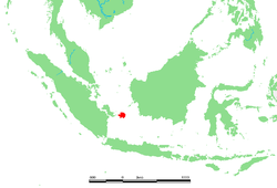
Fläche 4.478 km²
Höchste Erhebung Tajam
500 m
Einwohner 160.000
36 Einw./km²
Hauptort Tanjungpandan
Topographische Karte der Insel

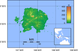
Belitung (auch Billiton) ist eine östlich von Sumatra in der Karimata-Straße gelegene indonesische Insel. Sie ist 4478 km² groß und erreicht im Tajam eine Höhe von rund 500 m. Wichtiger Wirtschaftszweig ist der Abbau von Zinnerz. Belitung wird von 160.000 Menschen bewohnt, Hauptort ist Tanjungpandan.

Im Westen liegt die Nachbarinsel Bangka. Beide Inseln bilden die indonesischen Provinz Bangka-Belitung.


Wikimedia Foundation.

Игры ⚽ Поможем написать курсовую

Schlagen Sie auch in anderen Wörterbüchern nach:

  • Belitung — [bə lē′tooŋ] island of Indonesia, in the Java Sea, between Borneo & Sumatra: 1,866 sq mi (4,833 sq km) * * * Be·li·tung (bə lēʹto͝ong) also Bil·li·ton (bə lēʹtŏn ) An island of western Indonesia in the Java Sea between Sumatra and Borneo. It has… …   Universalium

  • BELITUNG — BELITUNG, Indonésie Située dans la mer de Java, entre Sumatra Sud et Kalimantan Ouest, en Indonésie, séparée de l’île voisine de Bangka par le détroit de Gelasa, et s’étendant sur une superficie modeste (4 800 km2), l’île de Belitung (Belitoeng,… …   Encyclopédie Universelle

  • Belitung — [bə lē′tooŋ] island of Indonesia, in the Java Sea, between Borneo & Sumatra: 1,866 sq mi (4,833 sq km) …   English World dictionary

  • Belitung — 2° 50′ 00″ S 107° 55′ 01″ E / 2.83333, 107.917 …   Wikipédia en Français

  • Belitung — Infobox Islands name = Belitung image caption = Topography of Belitung island locator native name = native name link = location = South East Asia coordinates= coord|2|50|S|107|55|E|region:ID type:isle archipelago = total islands = major islands …   Wikipedia

  • Belitung — or Billiton geographical name island Indonesia between Sumatra & Borneo area 1866 square miles (4852 square kilometers), population 102,375 …   New Collegiate Dictionary

  • Belitung — Belịtung,   Billiton, Insel in der Provinz Sumatera Selatan, Indonesien, zwischen Sumatra und Borneo, 4 833 km2, 163 600 Einwohner, Hauptort ist Tanjungpandan; Abbau von Zinnerzen …   Universal-Lexikon

  • Belitung — Be•li•tung [[t]bɛˈli tɒŋ[/t]] also Billiton n. geg an island in Indonesia, between Borneo and Sumatra. 100,000; 1866 sq. mi. (4833 sq. km) …   From formal English to slang

  • Belitung — …   Useful english dictionary

  • Belitung, isla — o isla Billiton Isla en el centro–oeste de Indonesia. Está situada en el estrecho de Karimata (que la separa de Borneo hacia el nordeste) y se encuentra entre el mar de China meridional (por el norte) y el mar de Java (por el sur). Mide 88 km (55 …   Enciclopedia Universal

Share the article and excerpts

Direct link
Do a right-click on the link above
and select “Copy Link”