- Zuqualla
-
Zuqualla 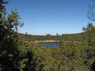
Der Kratersee
Höhe 2.998 m Lage Oromiyaa, Äthiopien Geographische Lage 8° 33′ 0″ N, 38° 52′ 0″ O8.5538.8666666666672998Koordinaten: 8° 33′ 0″ N, 38° 52′ 0″ O 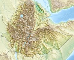

Typ erloschener Schichtvulkan Alter des Gesteins Pleistozän Der Zuqualla (oder Zukwala, Zuquala, Zuqwala) ist ein erloschener Schichtvulkan in der Region Oromiyaa in Äthiopien. Er befindet sich circa 30 Kilometer südlich von Debre Zeyit. Er erhebt sich 1100 Meter über dem umliegenden Gelände und ist insgesamt 2998 Meter hoch. Seine Basis hat einen Durchmesser von 12 Kilometern. Die Caldera hat zwei Kilometer Durchmesser und ist etwa 300 Meter tief.
Bekannt ist der Zuqualla für seinen Kratersee, der den äthiopischen Christen wie auch Anhängern von Naturreligionen als heilig gilt. Auf einer Insel des Kratersees befindet sich ein Kloster, angeblich von dem Heiligen Gebre Manfus gegründet. Dieses Kloster wurde zerstört und eine Kirche am Fuß des Berges von Imam Ahmad Gragn (dem "Linkshänder") 1531 geplündert. Es gibt noch viele heilige Plätze am und um den Berg, meistens künstliche Felsanordnungen. Halbjährlich richtet das Kloster ein Fest aus.
Weblinks
- Bild und Kurzinfo bei Oregonstate (englisch)
- Zuqualla im Global Volcanism Program der Smithsonian Institution (englisch)
Kategorien:- Zweitausender
- Berg in Afrika
- Berg in Äthiopien
- Schichtvulkan
- Geologie Afrikas

Wikimedia Foundation.