- Émaé
-
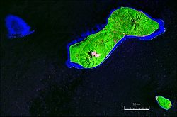
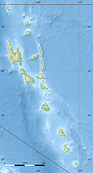
Emae NASA Geocover 2000-Satellitenbild. Im Süden ist die Insel Makura zusehen, und im Westen das Pula Iwa Reef (Cook Reef). Gewässer Pazifischer Ozean Inselgruppe Shepherd-Inseln Geographische Lage 17° 4′ S, 168° 23′ O-17.065477777778168.37693611111644Koordinaten: 17° 4′ S, 168° 23′ O Länge 11,4 km Breite 4,4 km Fläche 36,5 km² Höchste Erhebung Maunga Lasi
644 mEinwohner 743 (2009)
20 Einw./km²Hauptort Makata Émaé ist eine kleine Insel aus der Gruppe der Shepherd-Inseln des südpazifischen Inselstaats Vanuatu. Sie gehört der zentral-gelegenen vanuatuischen Provinz Shefa an.
Inhaltsverzeichnis
Geographie
Émaé ist vulkanischen Ursprungs; der Krater dieses zum größten Teil unterseeischen Vulkans ist von großer Ausdehnung. Die beiden nahegelegenen Nachbarinseln Makura und Matasu (7 bzw. 17 km südlich von Émaé) sind Teil seines Randes. Die höchste Erhebung dieses kleinen Archipels, Maunga Lasi (Mont Maunga) im Nordosten von Émaé, misst 644 m. Auch der zentrale (Mont Talimasa, 434 m) und der südwestliche Gipfel (Mont Painga oder Tavania Panga, 528 m) der Insel sind markant, sodass die Insel aus der Ferne als eine Gruppe von drei Inseln erscheint.[1][2]
4,6 km westlich von Émaé liegt das Pula Iwa Reef (Cook Reef), ein Atoll ohne Inseln, jedoch mit trockenfallenden Korallenstöcken.
Die Bevölkerung von Émaé, die knapp 750 zählt, ist rund acht Dörfer verstreut. Als Hauptort gilt Makata im Osten der Insel.
Der Flugplatz der Insel, Siwo Airport mit IATA-Code EAE und ICAO-Code NVSE, liegt im Südwesten beim Dorf Sangafa.
Bevölkerung und Wirtschaft
Die Insel ist in der Lage, eine Bevölkerung von ungefähr 750 Personen zu ernähren. Im Gegensatz zu den umliegenden Inseln, deren Bevölkerung Melanesier sind, haben die Bewohner von Émaé polynesische Wurzeln. Sie sprechen einen zum futunischen Zweig der polynesischen Sprachen gehörenden Dialekt des Polynesischen namens „Emae“. Die Insel gehört deshalb zu den außerhalb des polynesischen Dreiecks liegenden Exklaven Polynesiens.
Die Einwohner leben von einer einfachen Form der Landwirtschaft und betreiben Fischfang. Die Insel besitzt einen kleinen Flughafen. Viele der Insulaner leben heutzutage in Port Vila, der Hauptstadt Vanuatus.
Weblinks
- Krönung von vier Inselhäuptlingen in Port Vila
- UN Earthwatch Island site
- Ethnologische Seite für Émaé
Einzelnachweise
- ↑ Sailing Directions (enroute), Pub. 123, Seite
- ↑ Denis O'Bryrne, David Harcombe: Vanuatu. Lonely Planet Publications, 1999, Seite 136 (Karte)
Kategorien:- Insel (Vanuatu)
- Insel (Australien und Ozeanien)
- Insel (Pazifischer Ozean)
- Insel (Melanesien)
Wikimedia Foundation.


