Bourton-on-the-Water

Bourton-on-the-Water
City of Bourton-on-the-Water
Bourton-on-the-water

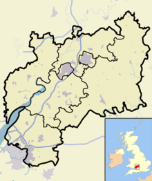
Lage in Gloucestershire
Basisdaten
Status Dorf
Region: South West England
Verwaltungsgrafschaft: Gloucestershire
Fläche: km²
Bevölkerung: 2.100 (2001, ca.)
Verwaltungssitz: Gloucestershire
ONS-Code:
Website: http://www.bourtoninfo.com
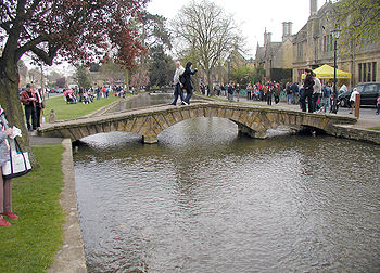
Die Fußgängerbrücke über den Fluss Windrush.

Bourton-on-the-Water ist ein Dorf in der Grafschaft Gloucestershire (County) in England im Cotswolds Gebiet.

Inhaltsverzeichnis

Geografie

Bourton-on-the-Water ist als das Venedig der Cotswolds bekannt; u. a. wegen mehrerer attraktiver kleiner Straßen und Fußgängerbrücken, die das Flüsschen Windrush überqueren.

Touristenattraktionen

  • Mittelalterliches Fußballspiel
  • Das Miniatur-Dorf (engl. The Modell Village) ist eine 1:9-Replik des Dorfes.
  • Eine Modelleisenbahn
  • Das Cotswold-Autofahrer-Museum
  • „Birdland“ ist ein Freizeitpark, der verschiedene Vögel zeigt. Kinder können Pinguine mit Fischen füttern und es gibt Greifvogel-Vorführungen.
  • Der Dragonfly-Maze-Irrgarten
  • Am jeden vierten Sonntag eines Monats gibt es einen Bauernmarkt.

Wanderwege

Langstreckenpfade und lokale Wanderwege beginnen oder enden hier oder führen durch Bourton-on-the-Water. Ein solcher Weg - Herz Englands Weg (Heart of England Way), der 100-Meilen-Weg führt nach Norden und beginnt hier. Die römische Straße Fosse-way führt in der Nähe von Bourton-on-the-water vorbei.

Schulen

  • Grundschule (Primary School)
  • Cotswold Schule, einer Gesamtschule (co-educational comprehensive school).

Bilder

Weblinks

 Commons: Bourton-on-the-Water – Sammlung von Bildern, Videos und Audiodateien
51.88641-1.75877

Wikimedia Foundation.

Игры ⚽ Нужно сделать НИР?

Schlagen Sie auch in anderen Wörterbüchern nach:

  • Bourton-on-the-Water — Infobox UK place official name= Bourton on the Water country= England region= South West England population= os grid reference= SP167209 latitude= 51.88641 longitude= 1.75877 post town= BOURTON ON THE WATER postcode area= GL postcode district=… …   Wikipedia

  • Bourton-on-the-Water — 51° 53′ 11″ N 1° 45′ 32″ W / 51.8864, 1.75877 …   Wikipédia en Français

  • Bourton on the Water — Original name in latin Bourton on the Water Name in other language Bourton on the Water State code GB Continent/City Europe/London longitude 51.86667 latitude 1.75 altitude 131 Population 3162 Date 2012 02 28 …   Cities with a population over 1000 database

  • Bourton-on-the-Water Railway — Die Bourton on the Water Railway war eine Eisenbahngesellschaft in Gloucestershire in England. Die Gesellschaft erhielt am 14. Juni 1860 das Recht zum Bau einer Bahnstrecke von Chipping Northern Junction in der Nähe von Kingham an der Strecke der …   Deutsch Wikipedia

  • Bourton — is the name of more than one place in England: * Bourton, Buckinghamshire * Bourton, Dorset * Bourton, North Somerset * Bourton, Cherwell, Oxfordshire * Bourton, Vale of White Horse, Oxfordshire * Bourton, Shropshire * Bourton on Dunsmore,… …   Wikipedia

  • The Cotswolds (UK Parliament constituency) — Coordinates: 51°45′22″N 1°46′08″W / 51.756°N 1.769°W / 51.756; 1.769 …   Wikipedia

  • Bourton-on-Dunsmore — infobox UK place country = England static static image caption= latitude= 52.32 longitude= 01.37 civil parish= Bourton and Draycote official name =Bourton on Dunsmore population = shire district= Rugby shire county= Warwickshire region= West… …   Wikipedia

  • Long-distance footpaths in the United Kingdom — The following long distance footpaths can be found in the United Kingdom:England and Wales: National TrailsNational Trails are distinguished by being maintained by the National Trails organization [http://www.nationaltrail.co.uk/] . As of|April… …   Wikipedia

  • Meet the Ancestors — BBC Book Cover Genre Documentary Presented by Julian Richards Country of origin …   Wikipedia

  • Telephone numbers in the United Kingdom — +44 redirects here. For the band, see +44 (band). United Kingdom telephone numbers Location of United Kingdom (dark green) Location Country United Kingdom Continent …   Wikipedia

Share the article and excerpts

Direct link
Do a right-click on the link above
and select “Copy Link”