Anthony Henday

Anthony Henday
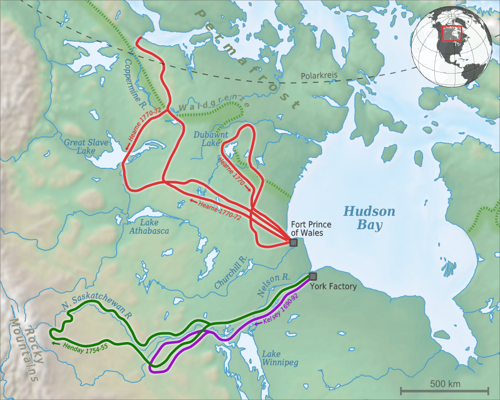
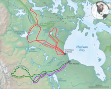
Anthony Hendays Expeditionsroute (grün).

Anthony Henday war ein britischer Entdecker, der im Auftrag der Hudson Bay Company eine Expedition in das Landesinnere von Kanada durchführte. Ausgehend von Fort York reiste er am 26. Juni 1754 mit Cree-Indianern auf derem Heimweg westwärts. Dabei drang er tief in die kanadische Prärie ein und bereiste die heutigen Provinzen Alberta und Saskatchewan. Nachdem er den Winter bei den Indianern verbrachte hatte, erreichte er im Juni 1755 seinen Ausgangspunkt Fort York wieder.


Wikimedia Foundation.

Игры ⚽ Поможем написать курсовую

Schlagen Sie auch in anderen Wörterbüchern nach:

  • Anthony Henday — (Hendry) (fl. 1750 ndash; 1762) was one of the first white men to explore the interior of the Canadian northwest. His explorations were authorized and funded by the Hudson s Bay Company because of their concern with La Verendrye and the other… …   Wikipedia

  • List of neighbourhoods in Edmonton — Map of Edmonton and adjoining St. Albert and Sherwood Park This is a list of residential neighbourhoods in Edmonton, Alberta, Canada. Unlike the category list, neighbourhoods are grouped geographically so that, to a greater or lesser degree, a… …   Wikipedia

  • Alberta Highway 216 — Infobox road province= AB alternate name= Anthony Henday Drive name notes= type=Hwy route=216 maint= Alberta Transportation section= length mi= length round= length ref= length notes= established= decommissioned= direction a= terminus a= beltway… …   Wikipedia

  • Haddow, Edmonton — Location map Edmonton lat = 53.453522 long = 113.596101 caption = Location of Haddow in Edmonton width = 220Haddow is a triangle shaped residential neighbourhood in south west Edmonton, Alberta, Canada. It is bounded on the south west by Anthony… …   Wikipedia

  • Ellerslie, Edmonton — Ellerslie is a newer residential neighbourhood in south Edmonton, Alberta, Canada.The most common type of residence in the neighbourhood is the single family dwelling. According to the 2005 municipal census, two out of every three residences… …   Wikipedia

  • MacEwan, Edmonton — MacEwan is a residential neighbourhood in south Edmonton, Alberta, Canada.Approximately half of the residences (52%) are single family dwellings according to the 2005 municipal census. Another three in ten (29%) are rented apartments and… …   Wikipedia

  • Cameron Heights, Edmonton — Cameron Heights is a new neighbourhood in west Edmonton, Alberta, Canada overlooking the North Saskatchewan River valley.It is bounded on the south by Anthony Henday Drive, on the north and west by a ravine, and on the east by the North… …   Wikipedia

  • Webber Greens, Edmonton — Webber Greens is a new neighbourhood in west Edmonton, Alberta, Canada. It is bounded on the east by Anthony Henday Drive and on the west by Winterburn Road. [City of Edmonton [http://maps.edmonton.ca map utility] ] The Anthony Henday provides… …   Wikipedia

  • Alberta Highway 15 — Highway 15 Route information Maintained by Alberta Transportation, the City of Edmonton, and the City of Fort Saskatchewan Length …   Wikipedia

  • Satoo, Edmonton — Satoo is a residential neighbourhood in the Mill Woods area of the City of Edmonton, Alberta, Canada. Satoo is one of three neighbourhoods in the Mill Woods community of Knottwood. [The other two neighborhoods in Knotwood are Ekota and Menisa.]… …   Wikipedia

Share the article and excerpts

Direct link
Do a right-click on the link above
and select “Copy Link”