Athboy

Athboy
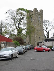
St James Church in Athboy (2006)

Athboy (irisch: Baile Átha Buí; dt.: „Siedlung der gelben Furt“) ist eine kleine landwirtschaftlich geprägte Stadt im County Meath im mittleren Osten der Republik Irland, die sich aus einer mittelalterlichen ummauerten Festung zu Pale-Zeiten entwickelte.

Inhaltsverzeichnis

Lage und Verkehrsanbindung

Athboy liegt am Yellow Ford River (auch Athboy River) im Westen der Grafschaft Meath, nahe der Grenze zum County Westmeath.[1] Mit Navan, der nächstgelegenen größeren Stadt, ist der Ort durch die Nationalstraße N51 verbunden; Mullingar an der N4 ist etwa 30 km[2] in südwestlicher Richtung entfernt. Die N51 trifft sich in Athboy mit der Regionalstraße R154. An den Schienenverkehr in Irland ist der Ort seit 1954 nicht mehr angeschlossen.

Demografie

Die Einwohnerzahl von Athboy wurde beim Census 2011 mit 2.522 Personen ermittelt. Die Stadt erlebt seit Mitte der 1990er-Jahre ein überdurchschnittlich starkes Bevölkerungswachstum; gegenüber 1991 (1083 Personen) hat sich die Einwohnerzahl bis 2011 mehr als verdoppelt.

Weblinks

Einzelnachweise

  1. Karte von Irland (stark vergrößerbar)
  2. Mullingar Map: „in Athboy, distanced approximately 30 km
53.623369-6.920767

Wikimedia Foundation.

Игры ⚽ Поможем написать реферат

Schlagen Sie auch in anderen Wörterbüchern nach:

  • Athboy — Église St James Administration Nom irlandais Baile Átha Buí Pays Irlande Province Leinster …   Wikipédia en Français

  • Athboy — Infobox Irish Place name = Athboy gaeilge = Baile Átha Buí crest motto = map pin coords = left: 50px; top: 65px north coord = 53.616667 west coord = 6.916667 irish grid = N800567 area = elevation = 61 m (200 ft) province = Leinster county =… …   Wikipedia

  • Athboy — Original name in latin Athboy Name in other language Athboy, Baile Atha Bui, Baile tha Bu State code IE Continent/City Europe/Dublin longitude 53.61861 latitude 6.92056 altitude 70 Population 1656 Date 2012 01 18 …   Cities with a population over 1000 database

  • Athboy — Sp Atbòjus Ap Athboy angliškai Ap Baile Átha Buí airiškai L Airija …   Pasaulio vietovardžiai. Internetinė duomenų bazė

  • Meath Senior Hurling Championship — For football equivalent see:Meath Senior Club Football Championship. Meath Senior Hurling Championship Irish Craobh Iomána Sinsear An Mhí Founded 1902 …   Wikipedia

  • N51 road (Ireland) — For the road in Luxembourg, see N51 road (Luxembourg). N51 road Route information Length: 59 km (37 mi) …   Wikipedia

  • Earl of Darnley — is at title that has been created three times, twice in the Peerage of Scotland and once in the Peerage of Ireland. The first creation in the Peerage of Scotland came in 1580 in favour of Esme Stewart, 1st Earl of Lennox. He was created Duke of… …   Wikipedia

  • Garden Party (festival) — infobox music festival music festival name = Garden Party caption = Garden Party 2007 location = Ballinlough Castle, Athboy, County Meath, Ireland years active= 2006 2007 dates = Saturday June 9 genre = Rock, Dance website =… …   Wikipedia

  • Clann na nGael GAA (Meath) — For the Drimoleague GAA club of the same name, see Clann na nGael GAA (Cork). Clann na nGael Founded: 2002 County: Meath …   Wikipedia

  • Meath Intermediate Football Championship 2011 — Meath I.F.C. Season 2011 Promoted Moynalvey Relegated Cortown Leinster ICFC Moynalvey (Preliminary Round) Ó Raghallaighs 0 14 Moynalvey 0 8 All Ireland ICFC N/A …   Wikipedia

Share the article and excerpts

Direct link
Do a right-click on the link above
and select “Copy Link”