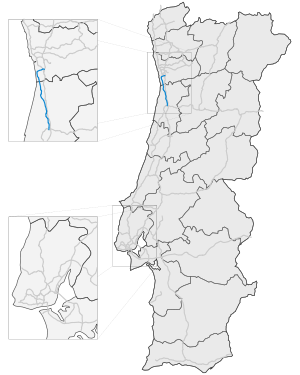
- Autoestrada A29
-
Autoestrada A 29 in Portugal Karte Basisdaten Betreiber: lusoscut CP Gesamtlänge: 52 km Straßenverlauf
(1) Porto 


(2) Porto-Hospital N 1399 
(3) Porto 

(4) Canelas N 623-1 

Área de Servicio Canelas 
(5) Gulpilhares 

(6) Miramar N 109 
(7) Granja N 109-2 
(8) Sao Félix da Marinha N 109 
(9) Espinho 

(10) Esmoriz-Norte N 1-14 
(11) Esmoriz-Sul N 527 
(12) Maceda N 223 

Área de Servicio Ovar 
(13) Ovar-Norte N 527 
(14) Ovar-Sul N 109 
(15) Estarreja N 224 
(16) Estarreja-Sul N 1-12 
(17) Angeja 
Die Autoestrada A29 oder Auto-Estrada da Costa de Prata ist eine Autobahn in Portugal. Die Autobahn beginnt in Porto und endet in Angeja.
Größere Städte an der Autobahn
Weblinks
- Anschlussstellen auf motorways-exitlists.com
Autobahnen 
A 1 · A 2 · A 3 · A 4 · A 5 · A 6 · A 7 · A 8 · A 9 · A 10 · A 11 · A 12 · A 13 · A 14 · A 15 · A 16 · A 17 · A 18 · A 19 · A 20 · A 21 · A 22 · A 23 · A 24 · A 25 · A 26 · A 27 · A 28 · A 29 · A 30 · A 31 · A 32 · A 33 · A 34 · A 35 · A 36 · A 37 · A 38 · A 39 · A 40 · A 41 · A 42 · A 43 · A 44 · A 45 · A 46 · A 47
Wikimedia Foundation.
Schlagen Sie auch in anderen Wörterbüchern nach:
List of autopistas and autovías in Spain — The Spanish motorway network is the fourth largest in the world by length, after the United States, China and Canada. As of 2008, there are 15,152 km (9,415 mi) of High Capacity Roads[1] (Sp. Vías de Gran Capacidad) in the country.… … Wikipedia


