Bistcho Lake

Bistcho Lake
Bistcho Lake

Photo-request.svg

Bild gesucht 

BW

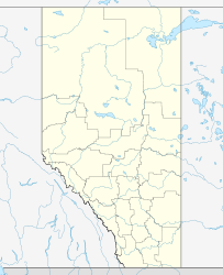
Geographische Lage NW von Alberta (Kanada)
Zuflüsse Petitot River
Abfluss Petitot RiverLiard RiverMackenzie River
Daten
Koordinaten 59° 44′ 0″ N, 118° 48′ 0″ W59.733333333333-118.8552Koordinaten: 59° 44′ 0″ N, 118° 48′ 0″ W
Bistcho Lake (Alberta)
Bistcho Lake
Höhe über Meeresspiegel 552 m
Fläche 413 km²[1]

Der Bistcho Lake ist mit einer Fläche von 413 km² einer der größten Seen Albertas.[1] Er liegt im äußersten Nordwesten der Provinz in einer Höhe von 552 m.[1] Die Gesamtfläche einschließlich Inseln beträgt 426 km².[1] Der Petitot River, ein rechter Nebenfluss des Liard River, durchfließt den See.

Einzelnachweise

  1. a b c d Natural Resources Canada - The Atlas of Canada - Lakes

Wikimedia Foundation.

Игры ⚽ Нужна курсовая?

Schlagen Sie auch in anderen Wörterbüchern nach:

  • Bistcho Lake — Infobox lake lake name = Bistcho Lake image lake = caption lake = image bathymetry = caption bathymetry = location = Alberta coords = Coord|display=inline,title|59|44|N|118|48|W|type:waterbody region:CA AB type = inflow = outflow = Petitot River… …   Wikipedia

  • Mobil Bistcho Airport — IATA: none – ICAO: none – TC LID: CFV3 Summary Airport type Public Operator Alberta Sustainable Resource Development, Forest Protection Division, High Level …   Wikipedia

  • Mobil Bistcho, Alberta — Mobil Bistcho is a grass airstrip in Northern Alberta.It is located along the 31st baseline.Alberta Sustainable Resources, (formerly the Alberta Forest Service), maintains the airstrip and maintains a remote forward basecamp and fuel cache for… …   Wikipedia

  • Maligne Lake — and Maligne Mountain Location Jasper National Park, Alberta Coordinates …   Wikipedia

  • Moraine Lake — For the type of lake, see moraine dammed lake. Moraine Lake Location Banff National Park, Alberta Coordinates …   Wikipedia

  • McGregor Lake — East Bank Location Vulcan County, Southern Alberta Coordinates …   Wikipedia

  • Cold Lake (Alberta) — Cold Lake Aerial photograph Location Bonnyville No. 87, Alberta / Beaver River No. 622, Saskatchewan Coordinates …   Wikipedia

  • Mud Lake (Alberta) — There are several lakes named Mud Lake within the Canadian province of Alberta. Mud Lake, located near Fort Macleod, Municipal District of Willow Creek, Alberta. 49°45′00″N 113°32′00″W /  …   Wikipedia

  • Medicine Lake (Alberta) — Medicine Lake Cedar strip freighter canoes (1991) Location Jasper National Park, Alberta Coordinates …   Wikipedia

  • McLeod Lake (Alberta) — McLeod Lake Location Woodlands County, Alberta Coordinates 54°17′47″N 115°39′12″W …   Wikipedia

Share the article and excerpts

Direct link
Do a right-click on the link above
and select “Copy Link”