Blackwall Point

Blackwall Point
Blick auf den Blackwall Point und das Kraftwerk von Osten (1973)
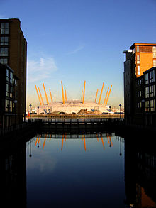
Blick auf The O₂ von Westen (2005)

Blackwall Point ist der nördlichste Punkt der Greenwich Peninsula im Londoner Eastend. Dieses Gebiet liegt am südlichen Ufer der Themse und gehört zum Londoner Stadtviertel Greenwich und nicht etwa zum nördlich der Themse liegenden Stadtteil Blackwall.

Benannt ist dieses Gebiet nach dem dortigen Flussabschnitt der Themse, dem Blackwall Reach.

Von den 1890er-Jahren bis 1980 war am Blackwall Point ein Kohlekraftwerk in Betrieb, die Blackwall Point Power Station. Heute steht dort The O₂, das auch als Millennium Dome bekannte, größte freitragende Gebäude im Vereinigten Königreich.


Wikimedia Foundation.

Игры ⚽ Нужна курсовая?

Schlagen Sie auch in anderen Wörterbüchern nach:

  • Blackwall — may refer to:*Blackwall, London An area of east London, UK **Blackwall Tunnel The main crossing of the River Thames in east London **Blackwall Yard A former shipyard at Blackwall, London **Blackwall Frigate A class of merchant sailing ship built… …   Wikipedia

  • Blackwall, London — This entry concerns the area of London known as Blackwall. For the type of merchant sailing ship first built there and named after it, see Blackwall Frigateinfobox UK place country = England map type = Greater London region= London population=… …   Wikipedia

  • Blackwall — Der Name Blackwall bezeichnet: folgende Personen: John Blackwall, britischer Naturforscher (1790–1881) folgende Orte in Großbritannien: Blackwall (London), ein Stadtviertel im Londoner Eastend Bahnhof Blackwall, frühere östliche Endstation der… …   Deutsch Wikipedia

  • Blackwall Reach (Western Australia) — Point WalterBlackwall Reach is a section of the Swan River in Western Australia. As a section of river it was named in the 1830s and referred to the the part of the river, not just one side of the river or other. It was in the twentieth century… …   Wikipedia

  • Blackwall Tunnel — Infobox tunnel name = Blackwall Tunnel caption = Entering the western of the two bores line = location = Blackwall / Greenwich coordinates = coord|51.504443| 0.003119|display=inline,title system = status = start = end = stations = open = close =… …   Wikipedia

  • Blackwall, New South Wales — Infobox Australian Place | type = suburb name = Blackwall city = Central Coast state = nsw caption = lga = City of Gosford postcode = 2256 pop = 1,858 (2006 census) area = 1.2 est = parish = Patonga stategov = Gosford fedgov = Robertson dist1 =… …   Wikipedia

  • Daleys Point, New South Wales — Daleys Point Central Coast, New South Wales Population: 528 (2006 census) Postcode: 2257 Area: 0.3 km² (0.1& …   Wikipedia

  • Cheero Point, New South Wales — Cheero Point Central Coast, New South Wales Population: 107 (2002 estimate)[1] Postcode: 2083 …   Wikipedia

  • Greenwich Peninsula — Coordinates: 51°29′53″N 0°00′23″E / 51.498131°N 0.006317°E / 51.498131; 0.006317 …   Wikipedia

  • Greenwich Peninsula — vom Canada Square aus mit dem O2 Komplex in der Mitte …   Deutsch Wikipedia

Share the article and excerpts

Direct link
Do a right-click on the link above
and select “Copy Link”