Blowering Dam

Blowering Dam
Blowering-Damm
Blowering Dam
Blowering Dam
Lage: New South Wales, Australien
Zuflüsse: Tumut River
Blowering-Damm (New South Wales)
Blowering-Damm
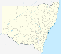
Koordinaten 35° 23′ 58,7″ S, 148° 14′ 32,8″ O-35.39965148.24244Koordinaten: 35° 23′ 58,7″ S, 148° 14′ 32,8″ O
Daten zum Bauwerk
Bauzeit: 1968
Höhe des Absperrbauwerks: 112 m
Daten zum Stausee
Speicherraum: 1.628.000 Megaliterdep1

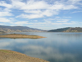
Der Blowering Dam ist ein Staudamm am Tumut River in New South Wales, Australien, der im Jahre 1968 fertiggestellt wurde. Der Damm bildet mit dem Blowering-Wasserwerk einen Teil des Snowy-Mountains-Systems.

Blowering Dam

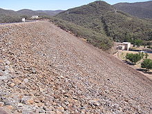
Der Damm ist 112 Meter hoch und wurde aus Erdaushub und Felsen geformt. Das Volumen des Wassers im Stausee beträgt 1.628.000 Megaliter (Millionen Liter). Das Wasser des Sees wird zur Bewässerung und zur Stromerzeugung verwendet.

Im April 2009 gab die Regierung von New South Wales den Auftrag, den Damm für $33 Millionen zu sichern, um Überflutungen zu verhindern. Die Baumaßnahme soll bis ins Jahr 2011 andauern.[1]

In dem Stausee befinden sich Forellen und Zander, die zum Teil geschützt sind.[2] Am Staudamm führt der Snowy Mountains Highway vorbei.

Der australische Rennbootsfahrer Ken Warby hält den aktuellen Geschwindigkeitsweltrekord von 511,13 km/h auf dem Wasser, den er am 8. Oktober 1978 auf dem Blowering Dam mit seinem Boot Spirit of Australia erreichte. Er ist bis heute der einzige Mensch, der auf dem Wasser schneller als 300 Meilen fuhr. Die Spirit of Australia hatte Warby selbst entworfen und gebaut.

Einzelnachweise

  1. $33m flood-prevention works set for Blowering Dam, The Daily Advertiser. 24. April 2009. Abgerufen am 4. Juni 2010. 
  2. Information auf sweetwaterfishing.com.au. Abgerufen am 4. Juni 2010

Wikimedia Foundation.

Игры ⚽ Поможем написать реферат

Schlagen Sie auch in anderen Wörterbüchern nach:

  • Blowering Dam — is on the Tumut River in Australia. It is part of the Snowy Mountains Scheme. Associated with the dam is the Blowering Power Station.The dam was completed in 1968. It holds 1,628,000 megalitres (million litres). The wall height is 112 m and is… …   Wikipedia

  • Blowering Dam — 35° 23′ 59″ S 148° 14′ 31″ E / 35.3997, 148.242 …   Wikipédia en Français

  • Blowering Dam — /blaʊərɪŋ ˈdæm/ (say blowuhring dam) noun a dam on the Tumut River in southern NSW; used for hydro electricity and irrigation …  

  • Blowering Power Station, New South Wales — The power station was completed in 1969, and has 86.6 metres rated hydraulic head. See also * Blowering Dam * Snowy Mountains Scheme * Snowy Hydro Limited External links * [http://www.snowyhydro.com.au/levelTwo.asp?pageID=244 parentID=242 Snowy… …   Wikipedia

  • Mangrove Creek Dam — is the primary reservoir for water supply to residents of the New South Wales Central Coast, operated by the Gosford/Wyong Councils Water Authority, a joint operation of the City of Gosford and Wyong Shire. It is formed by impounding the… …   Wikipedia

  • Snowy-Mountains-System — Talbingo Stausee …   Deutsch Wikipedia

  • Snowy Mountains Scheme — La ville de Jindabyne, a été déplacée en 1967 pendant la construction du Snowy Mountains Scheme. La ville originale a été inondée par le lac Jindabyne. Le plan d aménagement des Snowy Mountains (en anglais Snowy Mountains Scheme ou Snowy… …   Wikipédia en Français

  • Tumut River — ▪ river, New South Wales, Australia       river, south New South Wales, Australia. It rises on the northwestern slopes of the Snowy Mountains and flows 90 miles (145 km) to join the Murrumbidgee River, east of the town of Gundagai.       The… …   Universalium

  • Tumut River — Der Tumut River bei TumutVorlage:Infobox Fluss/KARTE fehlt DatenVorlage:Infobox Fluss/GKZ …   Deutsch Wikipedia

  • List of dams and reservoirs in Australia — Dams and reservoirs in Australia is a link page for any dam or reservoir in Australia. Contents 1 Australian Capital Territory 2 New South Wales 2.1 Cancelled 2.2 Weir …   Wikipedia

Share the article and excerpts

Direct link
Do a right-click on the link above
and select “Copy Link”