Boone Station State Historic Site
- Boone Station State Historic Site
-

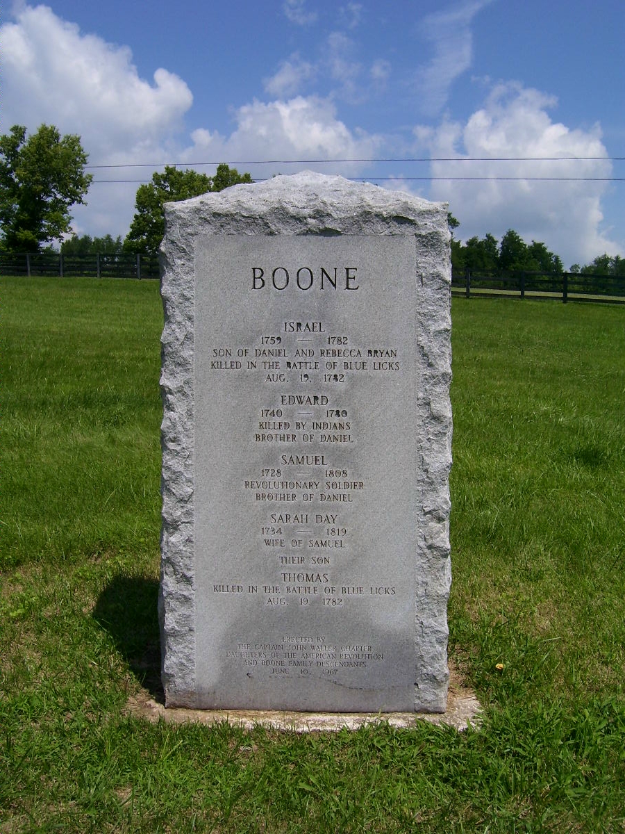
Gedenkstein in der Boone Station State Historic Site
Die Boone Station State Historic Site ist ein State Park im US-Bundesstaat Kentucky. Der 18 Hektar große Park liegt bei Lexington im Fayette County. Im Dezember 1779 gründete der amerikanische Pionier Daniel Boone und seine Familie Boone Station, nach dem ihnen die Siedlung Boonesborough zu groß wurde. In ihrer Blütezeit wohnten 15 bis 20 Familien in Boone Station. Daniel Boone und seine Familie hatten schwere Schicksalsschläge in der Zeit, als sie in Boone Station lebten. Sein Sohn Israel und sein Neffe Thomas Boone fielen in der Schlacht bei Blue Licks 1781, sein Bruder Edward wurde im Bourbon County von Indianern getötet. Zudem wurde 1781 ihr Besitzanspruch auf Boone Station ungültig, so dass Boone und die anderen Siedler die Siedlung verlassen mussten. 1791 war die Siedlung völlig verlassen, 1795 kaufte ein Robert Frank über 200 Hektar Land inklusive dem Gelände von Boone Station und errichtete hier für seine Familie ein neues Haus. Daniel Boone zog mit seiner Familie schließlich ins Louisiana-Territorium. Das Gelände der ehemaligen Boone Station wurde 1991 von Robert C. Strader dem Staat Kentucky geschenkt, der hier 1992 den State Park eröffnete. Auf die frühere Pionieransiedlung weisen allerdings nur ein Gedenkstein und Informationstafeln hin. Im Park gibt es einen ein Kilometer langen Rundweg und Picknickmöglichkeiten.
Weblinks
Literatur
- Susan Reigler: The complete Guide to Kentucky State Parks. Lexington: University Press of Kentucky 2009, ISBN 978-0-8131-9208-6
37.95313-84.35498
Wikimedia Foundation.
Schlagen Sie auch in anderen Wörterbüchern nach:
Constitution Square State Historic Site — Type Kentucky state park Location … Wikipedia
Dr. Thomas Walker State Historic Site — Replica of Dr. Thomas Walker s cabin Dr. Thomas Walker State Historic Site is a park in Barbourville, Kentucky in Knox County. The land was donated by the American Legion and the city of Barbourville, and marks the area where Kentucky pioneer Dr … Wikipedia
Old Mulkey Meetinghouse State Historic Site — is a 20 acre (8.1 ha) park in Monroe County, Kentucky. It features the Old Mulkey Meetinghouse, a Baptist church built around the turn of the 19th century, and its adjacent cemetery. The site became part of the park system in 1931.[1] The… … Wikipedia
Boone Station — (or Boone s Station) was a settlement in Kentucky and the home of Daniel Boone from 1779 to 1782. It was located on Boone s Creek in Fayette County, Kentucky, near present Athens, Kentucky. Boone moved here during the American Revolutionary War… … Wikipedia
State Parks in Kentucky — Der US Bundesstaat Kentucky unterhält 52 State Parks (Stand: November 2010). Die State Parks in Kentucky werden vom Kentucky Department of Parks verwaltet. Geschichte Die Generalversammlung Kentuckys schuf 1924 die State Parks Commission, um… … Deutsch Wikipedia
Martin Luther King, Jr., National Historic Site — This article is about the National Historic Site in Atlanta, GA. For the article about the Memorial in Washington, D.C., see Martin Luther King, Jr. Memorial King, Martin Luther, Jr., National Historic Site and Preservation District U.S. National … Wikipedia
List of Registered Historic Places in Missouri, Counties O-St. — NOTOC List of Registered Historic Places in Missouri, Counties O St.::: Missouri NRHP date for lists =Oregon County= * Alton ** Greer Mill *Riverton ** Pigman Mound Archeological Site =Osage County= *Bonnots Mill ** Bonnots Mill Historic District … Wikipedia
My Old Kentucky Home State Park — My Old Kentucky Home U.S. National Register of Historic Places … Wikipedia
National Register of Historic Places listings in Boyle County, Kentucky — Location of Boyle County in Kentucky This is a list of the National Register of Historic Places listings in Boyle County, Kentucky. This is intended to be a complete list of the properties and districts on the National Register of Historic Places … Wikipedia
National Register of Historic Places listings in North Carolina — Map of all coordinates from Google Map of all coordinates from Bing Export all coordinates … Wikipedia