California State Route 145
Schlagen Sie auch in anderen Wörterbüchern nach:
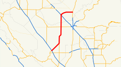
California State Route 145 — Infobox road state=CA type=SR route=145 section=445 maint=Caltrans length mi=67 length round=0 length ref= [ [http://www.dot.ca.gov/hq/structur/strmaint/brlog2.htm January 1, 2006 California Log of Bridges on State Highways] ] direction a=South… … Wikipedia
California State Route 269 — Infobox road state=CA type=SR route=269 section=569 maint=Caltrans length mi=30 length round=0 length ref= [ [http://www.dot.ca.gov/hq/structur/strmaint/brlog2.htm January 1, 2006 California Log of Bridges on State Highways] ] direction a=South… … Wikipedia
California State Route 86 — Karte … Deutsch Wikipedia
California State Route 41 — CA 41 redirects here. For the congressional district, see California s 41st congressional district. State Route 41 … Wikipedia
California State Route 33 — CA 33 redirects here. For the congressional district, see California s 33rd congressional district. State Route 33 … Wikipedia
California State Route 91 — Infobox road state=CA type=SR route=91 alternate name=Artesia Boulevard, Gardena Freeway, Artesia Freeway, Riverside Freeway section=391 maint=Caltrans length mi=59.047 length round=3 length ref= history=1930s as a highway; 1964 as number… … Wikipedia
California State Route 146 — Infobox road state=CA type=SR route=146 section=446 maint=Caltrans length mi=13 length round=0 length ref= [ [http://www.dot.ca.gov/hq/structur/strmaint/brlog2.htm January 1, 2006 California Log of Bridges on State Highways] ] direction a=West… … Wikipedia
California State Route 118 — Infobox road state=CA type=SR route=118 alternate name=Ronald Reagan Freeway section=418 maint=Caltrans length mi=46.68 length round=2 length ref= [ [http://www.dot.ca.gov/hq/structur/strmaint/brlog2.htm January 1, 2006 California Log of Bridges… … Wikipedia
California State Route 150 — Infobox road state=CA type=SR route=150 section=450 maint=Caltrans length mi=36 length round=0 length ref= [ [http://www.dot.ca.gov/hq/structur/strmaint/brlog2.htm January 1, 2006 California Log of Bridges on State Highways] ] direction a=West… … Wikipedia
California State Route 144 — Infobox road state=CA type=SR route=144 section=444 maint=Caltrans length mi=2 length round=0 length ref= [ [http://www.dot.ca.gov/hq/structur/strmaint/brlog2.htm January 1, 2006 California Log of Bridges on State Highways] ] direction a=South… … Wikipedia
 I-5 im Zentrum des San Joaquin Valley
 CA 41 nördlich von Fresno
