Cobourg Peninsula

Cobourg Peninsula
Cobourg Peninsula
Satellitenbild der Cobourg Peninsula
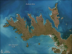
mit der Croker Island
Satellitenbild der Cobourg Peninsula
mit der Croker Island
Gewässer 1 Arafurasee
Gewässer 2 Van-Diemen-Golf, Dundas Strait

Geographische Lage

11° 22′ 0″ S, 132° 18′ 0″ O-11.366666666667132.3Koordinaten: 11° 22′ 0″ S, 132° 18′ 0″ O
Cobourg Peninsula (Northern Territory)
Cobourg Peninsula
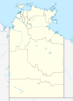
Länge 100 km
Breite 38 km
Fläche 2.100 km²
Karte mit der Cobourg Peninsula

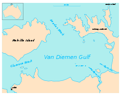
Die Cobourg Peninsula ist eine Halbinsel 350 km östlich von Darwin im Northern Territory in Australien. Sie ist stark gegliedert mit kleinen und größeren Buchten. Ihre Fläche beträgt 2100 km². Sie ist spärlich besiedelt. Ihre Einwohnerzahl beträgt zwischen 20 und 30 und verteilt sich auf 5 Family outstations:

  • Araru Point (Araru)
  • Ardbinae (Adbanae, Trepang Bay)
  • Gumuragi (Gumeragi, Reef Point)
  • Meriah (Mariah, Raffles Bay)
  • Irgul (Irgul Point)
  • Gul Gul (Danger Point) (verlassen, Ruine)

Weitere Einrichtungen sind der Leuchtturm Cape Don Light ganz im Westen, sowie der nahegelegene Flugplatz Cape Don Airport (ICAO-Code YCPD, Gras, Landebahn 1800 m, eröffnet am 8. November 1989), die Ranger-Station Algarlalgari (Black Point) und der Campingplatz Ngardimardi (Smith Point).

Außerdem lag die Siedlung Port Essington auf der Halbinsel. Die Bowen Strait trennt die Halbinsel im Osten von der Croker Island. Im Westen wird sie durch die Dundas Strait von der Melville Island getrennt.


Die Cobourg Peninsula ist Teil des Garig Gunak Barlu National Park, welcher außerdem noch einige küstennahe Inseln umfasst. Als Touristenattraktion ist sie wegen ihrer ursprünglichen Wildnis bekannt.


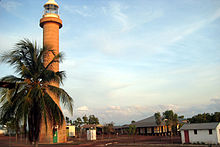
Leuchtturm Cape Don Light am westlichen Ende der Cobourg Peninsula

Wikimedia Foundation.

Игры ⚽ Нужен реферат?

Schlagen Sie auch in anderen Wörterbüchern nach:

  • Cobourg Peninsula — Image of Cobourg Peninsula with Croker Island top right Cape Don …   Wikipedia

  • Cobourg Peninsula — ▪ peninsula, Northern Territory, Australia also spelled  Coburg,         northwestern extremity of Arnhem Land, Northern Territory, Australia. The peninsula consists of a narrow neck of land extending about 60 miles (100 km) to Cape Don on Dundas …   Universalium

  • Cobourg Peninsula Sanctuary — noun an area of land on the Cobourg Peninsula, NT, which in 1981 was handed back to its traditional Aboriginal owners; formerly operated as a wildlife sanctuary; with the adjoining marine park forms the Garig Gunak Barlu National Park; a Ramsar… …  

  • Cobourg Peninsula — /koʊbɜg pəˈnɪnʃələ/ (say kohberg puh ninshuhluh) noun a narrow extension of land in the north western extremity of Arnhem Land, NT. About 96 km long …  

  • Péninsule de Cobourg — Vue satellite de la péninsule de Cobourg avec l île Croker dans le coin supérieur droit. Localisation Pays …   Wikipédia en Français

  • Banteng — Taxobox name = Banteng status = EN | status system = IUCN2.3 image width = 250px image caption = Java banteng (bull) regnum = Animalia phylum = Chordata classis = Mammalia ordo = Artiodactyla familia = Bovidae subfamilia = Bovinae genus = Bos… …   Wikipedia

  • Croker Island (Northern Territory) — Croker Island Satellitenbild von Croker Island mit der Cobourg Peninsula Gewässer Arafurasee …   Deutsch Wikipedia

  • List of peninsulas — A peninsula is a piece of land that is nearly surrounded by water but connected to mainland via an isthmus. A peninsula can also be a headland, cape, island promontory, bill, point, or spit. [ [http://www.britannica.com/ebi/article 9276348… …   Wikipedia

  • Port Essington — ▪ inlet, Northern Territory, Australia       inlet of the Arafura Sea, indenting the north shore of the Cobourg Peninsula, at the extreme north of the Northern Territory, Australia. About 19 miles (30 km) long and 7 miles (11 km) wide, it was… …   Universalium

  • Principal national parks of the world — ▪ Table Principal national parks of the world Africa Europe and Russia Asia North America and the Caribbean Australia and Oceania South America Africa country national park date area description protected status national park status square miles… …   Universalium

Share the article and excerpts

Direct link
Do a right-click on the link above
and select “Copy Link”