Contwoyto Lake

Contwoyto Lake
Contwoyto Lake

Photo-request.svg

Bild gesucht 

BW

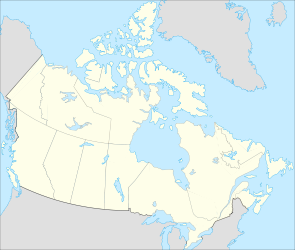
Geographische Lage Kitikmeok-Region in Nunavut, Nordwest-Territorien (Kanada)
Zuflüsse Contwoyto River
Abfluss Burnside River
Daten
Koordinaten 65° 38′ 59″ N, 110° 43′ 0″ W65.649722222222-110.71666666667564Koordinaten: 65° 38′ 59″ N, 110° 43′ 0″ W
Contwoyto Lake (Kanada)
Contwoyto Lake
Höhe über Meeresspiegel 564 m
Fläche 933 km²[1]
Länge 110 kmf6

Contwoyto Lake ist ein See in der Kitikmeot-Region des kanadischen Territoriums Nunavut an der Grenze zu den Nordwest-Territorien. Die Wasserfläche des Sees beträgt 933 km², mit Inseln beträgt die Gesamtfläche 957 km².[1] Ein wichtiger Zufluss ist der Contwoyto River, der in sein Ostende mündet. Der Contwoyto Lake wird vom Burnside River nach Norden hin zum Bathurst Inlet, einer Bucht im Coronation Gulf, entwässert. Die Winterstraße Tibbitt to Contwoyto Winter Road stellt eine Verkehrsverbindung zum See dar.

Einzelnachweise

  1. a b Natural Resources Canada - The Atlas of Canada - Lakes

Wikimedia Foundation.

Игры ⚽ Поможем решить контрольную работу

Schlagen Sie auch in anderen Wörterbüchern nach:

  • Contwoyto Lake — Location Kitikmeot Region, Nunavut Coordinates 65°40′N …   Wikipedia

  • Contwoyto Lake — Sp Kòntvoito ẽžeras Ap Contwoyto Lake L Kanadoje (ŠV teritorijos) …   Pasaulio vietovardžiai. Internetinė duomenų bazė

  • Tibbitt to Contwoyto Winter Road — is a km to mi|num=568|abbr=no|spell=Commonwealth|precision=0|wiki=yes long annual ice road first built in 1982 to service mines and exploration activities in the Northwest Territories and Nunavut in northern Canada. The road is the world s… …   Wikipedia

  • Tibbitt to Contwoyto Winter Road — Die Tibbitt to Contwoyto Winter Road ist eine 568 km lange Eisstraße in den Nordwest Territorien und dem Territorium Nunavut im Norden Kanadas. Sie wird jährlich für einen Zeitraum von ca. 60 Tagen errichtet und führt zu 87% über zugefrorene …   Deutsch Wikipedia

  • Tibbitt Lake — Infobox lake lake name = Tibbitt Lake image lake = caption lake = image bathymetry = caption bathymetry = location = Northwest Territories coords = type = inflow = outflow = catchment = basin countries = Canada length = width = area = depth = max …   Wikipedia

  • Snap Lake Diamond Mine — Die Snap Lake Diamantenmine liegt 220 km nordöstlich von Yellowknife in den kanadischen Northwest Territories. Sie wird von De Beers, dem größten Diamantenproduzent und händler der Welt betrieben. Laut De Beers wird sie bei Fertigstellung ihr… …   Deutsch Wikipedia

  • Nettilling Lake — is in the southern part of the island, being the upper of the two visible lakes. The lower lake is Amadjuak Lake. Location Baffin Island, Nunavut Territory …   Wikipedia

  • Dubawnt Lake — Location Kivalliq Region, Nunavut Coordinates 63°4′0″N …   Wikipedia

  • Henik Lake — North Henik Lake Location Kivalliq Region, Nunavut Coordinates 61°43′59″N …   Wikipedia

  • Nueltin Lake — Location Manitoba/Nunavut Coordinates 60°09′03″N 099°45′ …   Wikipedia

Share the article and excerpts

Direct link
Do a right-click on the link above
and select “Copy Link”