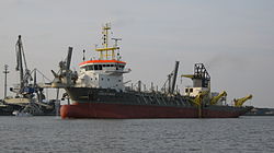
Crestway

Crestway
Crestway
Crestway im Jahr 2010 vor Nordenham

Crestway im Jahr 2010 vor Nordenham

p1
Schiffsdaten
Flagge Zypern
Schiffstyp Baggerschiff
Rufzeichen 5BLJ2
Eigner Royal Boskalis Westminster nv
Bauwerft IHC Merwede B.V.
Stapellauf 2008
Verbleib in Betrieb
Schiffsmaße und Besatzung
Länge
97,5 m (Lüa)
Breite 21,6 m
Tiefgang max. 7,1 m
Vermessung 5500 GRT
 
Besatzung 14
Maschine
Maschinen-
leistung
6776 kW
Geschwindigkeit max. 15,5 kn (29 km/h)
Ausstattung
Baggertank

5600 m³

Baggertiefe

33 m

Saugrohrdurchmesser

1 m

Sonstiges
Registrier-
nummern

IMO-Nr.: 9420332

Die Crestway ist ein modernes Baggerschiff, das häufig auf deutschen Seeschifffahrtsstraßen Fahrwasser ausbaggert.

Das Schiff

Die Crestway arbeitet nach dem Prinzip eines Hopperbaggers. Das Baggerschiff hat an seiner Backbordseite ein Saugrohr, das es bei langsamer Fahrt auf den Gewässergrund herunterlässt um zu baggern. Im Schiff setzen sich die festen Bestandteile des Sauggutes ab und die Wasseranteile laufen zurück ins Wasser. Die festen Bestandteile des Sauggutes werden abtransportiert und können an anderer Stelle aufgespült werden. Die Crestway eignet sich daher besonders gut für das Ausbaggern von Häfen, Unterhalten von Fahrrinnen und Fahrwassern so wie das Aufspülen von Sand im Bereich des Küstenschutzes.

Das Schwesterschiff der Crestway mit gleichen Maßen und gleicher Ausstattung heißt Shoreway.

Weblinks


Wikimedia Foundation.

Игры ⚽ Нужен реферат?

Schlagen Sie auch in anderen Wörterbüchern nach:

  • Barrhaven — A group of homes in Barrhaven Barrhaven is a rapidly growing suburban neighbourhood in the southwest of the urban area of the city of Ottawa, Ontario, Canada, about 17 km (11 mi) southwest of downtown Ottawa. Prior to amalgamation with… …   Wikipedia

  • National Register of Historic Places listings in Sedgwick County, Kansas — Location of Sedgwick County in Kansas This is a list of the National Register of Historic Places listings in Sedgwick County, Kansas. This is intended to be a complete list of the properties and districts on the National Register of Historic… …   Wikipedia

  • Woodroffe Avenue — (Ottawa Road #15) is the major north south arterial road in Ottawa, Ontario, Canada s west end. It runs south from the Ottawa River Parkway through Baseline Road to Prince of Wales Drive towards the communities of Manotick and Barrhaven. The road …   Wikipedia

  • OC Transpo Route 95 — Map with Route 95 shown in green OC Transpo Route 95 is the Ottawa transit network s busiest route, running on the Transitway across the city. The termination points are located at Marketplace, at Fallowfield Station and in Orléans, at Place d… …   Wikipedia

  • Strandherd Drive — is a major road serving the community of Barrhaven in southwest Ottawa.Up until the mid 1990s, Strandherd Drive was an east west coursing road extending from Moodie Drive to Woodroffe Avenue. With the introduction of Highway 416 and the growth of …   Wikipedia

  • Hopperbagger — Geopotes 15 vollbeladen am 4. Mai 2007 vor Cuxhaven Ein Hopperbagger ist ein selbstfahrendes Laderaumsaugbaggerschiff, mit dem das Baggergut (festes Material) durch Schleppköpfe von der Gewässersohle gelöst und durch ein Saugrohr in die… …   Deutsch Wikipedia

  • Hampton Inn Garden City — (Garden City,США) Категория отеля: 2 звездочный отель Адрес: 2505 East Crestway Drive …   Каталог отелей

Share the article and excerpts

Direct link
Do a right-click on the link above
and select “Copy Link”