Dun Dornaigil

Dun Dornaigil

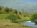
Dun Dornaigil (auch Dornadilla genannt) ist ein Broch in der Grafschaft Sutherland mitten in den schottischen Highlands. Er liegt bei Alltnacaillich genau südlich des Loch Hope.

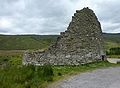
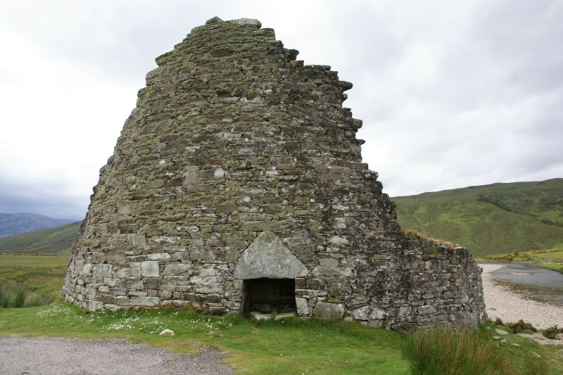
Die Ringmauer ist lediglich über dem Eingang noch 6,7 m hoch während der Rest nur noch ungefähr 2,4 m hoch ist. Über dem Eingang liegt ein gewaltiger Dreieckssturz. Das Innere des hohen Wandteils ist zusammengebrochen, und ein Betonpfeiler stützt die Fassade. Grund für den Zusammenbruch ist, dass der Broch am Rand einer Flussterrasse über dem Strathmore gebaut wurde, der mäandrierte und seinen Lauf über die Jahrhunderte verlegte.

Innerhalb der Mauer befinden sich eine Steintreppe und mehrere schmale Galerien. Der Innenraum hat 14,5 m Durchmesser. Der Broch ist nicht ausgegraben worden und liegt voller Trümmer.

Literatur

  • Anna Ritchie: Scotland BC. An introduction to the prehistoric houses, tombs, ceremonial monuments and fortifications in the care of the Secretary of State for Scotland. Scottish Development Dept., Edinburgh 1989, ISBN 0-11-493427-4.
  • Ian Armit: Towers in the North. The Brochs of Scotland. Tempus, Stroud 2003, ISBN 0-7524-1932-3.
  • Ian Armit: Broch Building in Northern Scotland. The Context of Innovation. In: World Archaeology 21 (Architectural Innovation), 1990, 3, ISSN 0043-8243, S. 435–445.
58.366324-4.639379

Wikimedia Foundation.

Игры ⚽ Нужно решить контрольную?

Schlagen Sie auch in anderen Wörterbüchern nach:

  • Dun Dornaigil — is an Iron Age broch in Sutherland in the Scottish Highlands. It is located at grid reference NC 4571 4501 next …   Wikipedia

  • Dun Carloway — Coordinates: 58°16′10.35″N 6°47′38.47″W / 58.2695417°N 6.7940194°W / 58.2695417; 6.7940194 …   Wikipedia

  • Broch — A Broch is an Iron Age drystone hollow walled structure of a type found only in Scotland. Brochs include some of the most sophisticated examples of drystone architecture ever created, and belong to the classification complex Atlantic Roundhouse… …   Wikipedia

  • Glenelg, Highland — Coordinates: 57°12′43″N 5°37′26″W / 57.212°N 5.624°W / 57.212; 5.624 …   Wikipedia

  • Broch of Mousa — Shoreside location of Mousa Broch Mousa Broch interior …   Wikipedia

  • Broch of Clickimin — The approach to Clickimin broch The Broch of Clickimin broch (also Clickimin broch) is a large and well preserved, though somewhat restored broch near the town of Lerwick in Shetland, Scotland. Originally built on an island in a small loch… …   Wikipedia

  • Old Scatness — wheelhouse …   Wikipedia

  • Broch of Culswick — Culswick Broch is an unexcavated coastal broch in the Shetland Islands of Scotland at …   Wikipedia

  • Carn Liath (broch) — Carn Liath broch Càrn Liath (English: Grey Cairn) is an Iron Age broch on the eastern shore of the Scottish Highlands, near Golspie, Sutherland. The broch was first excavated in the 19th century by the Duke of Sutherland, and was initially… …   Wikipedia

  • The Crucible of Iron Age Shetland — Broch of Mousa The Crucible of Iron Age Shetland is a combination of three sites in Shetland that have applied to be on the United Kingdom Tentative List of possible nominations for the UNESCO World Heritage Programme list of sites of outstanding …   Wikipedia

Share the article and excerpts

Direct link
Do a right-click on the link above
and select “Copy Link”