- Epping (New South Wales)
-
Epping 
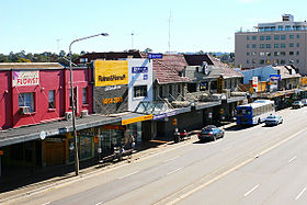
Beecroft Road vom Bahnhof ausStaat:  Australien
Bundesstaat:  New South Wales
Gegründet: 1899 Koordinaten: 33° 46′ S, 151° 5′ O-33.774722222222151.07888888889Koordinaten: 33° 46′ S, 151° 5′ O Einwohner: 18.970 (2006) [1] Zeitzone: AEST (UTC+10) Postleitzahl: 2121 LGA: Hornsby Shire, Parramatta City, Ryde City Epping ist ein Vorort von Sydney in Australien, 18 km nordwestlich der Innenstadt von Sydney. Er gehört zu den Local Government Areas Ryde City, Parramatta City und Hornsby Shire und den nördlichen Vororten von Sydney.
Inhaltsverzeichnis
Geschichte
Der Aborigines-Stamm der Wallumedegal lebte auf dem Gebiet zwischen Lane Cove River und Parramatta River.
1792 begann Gouverneur Phillip mit der Verteilung von Land an Angehörige der britischen Marine. Das Gebiet hieß auf Phillips Karten Field of Mars (Mars ist der römische Gott des Krieges). Es umfasste die Ländereien des heutigen Epping, Ryde und Marsfield.
Der Bahnhof von Epping hieß ursprünglich Field of Mars und später Carlingford. Das erste Postamt entstand in East Carlingford. 1899 benannte man den Vorort nach dem Vorschlag des Landbesitzers William Midson (1849–1924) in Epping um. Midsons Vater war in Epping (Essex) in England geboren[2].
Wirtschaft
Epping hat ein kleines Einkaufszentrum in der Nähe des Bahnhofes. Weiteres Gewerbe und auch Industrie liegen ebenfalls in der Gegend.
Der Epping RSL Club ist ein populärer Treffpunkt, der viele Gäste, auch Studenten der nahegelegenen Macquarie University anzieht. Im ‚’Epping Hotel’’ gibt es auch ein Bar mit eigenem Nachtclub.
Bis 2009 waren in Epping einige Fernsehstudios des Senders Seven Network angesiedelt.
Verkehr
Der Bahnhof Epping liegt an der Northern Line der CityRail von Sydney. Die Eisenbahnlinie Epping–Chatswood, die seit 2009 voll in Betrieb ist, startet ebenfalls am Bahnhof Epping. In der zweiten Ausbaustufe sollte diese Linie bis nach Parramatta verlängert werden, aber dieses Projekt wurde zunächst auf unbestimmte Zeit zurückgestellt.
Epping ist auch gut an das Stadtbusnetz von Sydney und an das Hillsbus-Netz angeschlossen. Der M2 Hills Motorway verläuft an der Nordseite von Epping zum Stadtzentrum von Sydney. Die Epping Road, eine wichtige Hauptstraße, verläuft vom Bahnhof aus östlich bis zum Pacific Highway.
Kirchen
- Chester Street Uniting Church
- Chinese Lutheran Church[3]
- Emmaus Bible College
- Epping Baptist Church
- Epping Church of Christ
- Epping Gospel Chapel
- Epping Presbyterian Church
- Epping Seventh-day Adventist Church[4]
- North Side Chinese Alliance Church
- Northern Districts Chinese Christian Church
- Our Lady Help of Christians (römisch-katholische Kirche)
- Oxford Street Uniting Church
- Presbyterian Reformed Church Epping
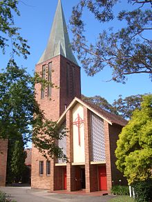
- St. Alban (Anglikanische Kirche) und St.. Aiden (Anglikanische Kirche in West Epping, gehört zur selben Gemeinde)
- St. Mark's Lutheran Church[5]
- West Epping Uniting Church
Schulen
- Arden Anglican School (früher katholische Mädchenschule Our Lady of Mercy College)
- Epping Boys High School (in Marsfield)
- Epping Heights Public School
- Epping North Public School
- Epping Public School
- Epping West Public School
- Our Lady Help of Christians Catholic Primary School[6]
Bevölkerung
Laut der Volkszählung 2006 hat Epping 18.970 Einwohner, wovon 9.216 (48,6 %) männlich und 9.754 (51,4 %) weiblich sind[1]. Ca. 53,6 % der Einwohner Eppings sind in Australien geboren. Die größte Einwanderergruppe stellt China (8,2 %), gefolgt von Hongkong (5,6 %), Korea (5,0 %), Indien (3,6 %) und dem Vereinigten Königreich (2,6 %).
Epping ist als aufstrebende Gemeinde bekannt, was auch an höheren Grundstückspreisen im Vergleich zu ihren Nachbargemeinden abzulesen ist. Der Anteil an Berufstätigen ist in Epping ist fast doppelt so hoch wie in Sydney[7].
Bekannte Einwohner
Maureen Nyholm (geborene Richardson) – Krankenschwester und Frau von Sir Ronald Sydney Nyholm aus Broken Hill wurde hier geboren.
Verwaltung
Epping ist auf drei LGAs aufgetreilt: Hornsby Shire, Parramatta City und (zum kleinsten Teil) Ryde City.
Bei den Parlamentswahlen für den Staat New South Wales bildet Epping einen eigenen Wahlkreis, bei den Wahlen zum australischen Bundesparlament gehört der Vorort zum Wahlkreis Bennelong.
Weblinks
 Commons: Epping – Sammlung von Bildern, Videos und Audiodateien
Einzelnachweise
- ↑ a b Australian Bureau of Statistics (25. Oktober 2007): Epping (State Suburb) (Englisch). 2006 Census QuickStats. Abgerufen am 15. März 2008.
- ↑ Frances Pollon: The Book of Sydney Suburbs. Angus & Robertson Publishers (1990). ISBN 0-207-14495-8. S. 100
- ↑ Website der Chinese Lutheran Church (englisch)
- ↑ Website der Seventh-day Adventist Church (englisch)
- ↑ Lutherische Kirche Australiens (englisch)
- ↑ Our Lady Help of Christians Catholic Primary School
- ↑ Profil des Vorortes Epping bei Domain.com.au (englisch)
Kategorie:- Stadtteil von Sydney
Wikimedia Foundation.


